The London Borough of Barnet, situated in North London, contains a dense collection of historical assets spanning over eight centuries of urban and military development. As a vital coaching stop on the Great North Road, this geographic region evolved from a strategic medieval flashpoint into a prosperous Victorian suburban enclave. This comprehensive guide details the architectural evolutions, archaeological boundaries, and preserved landmarks that define Barnet’s structural heritage.
- What Is the Historical Significance of the Battle of Barnet and Where Did It Take Place?
- How Did the Great North Road Shape the Development of Chipping Barnet?
- What Are the Architectural Elements of Monken Hadley Church and Its Beacon?
- How Did the Church of St John the Baptist Evolve through the Centuries?
- What Role Did Queen Elizabeth’s School Play in Barnet’s Educational History?
- Why Is the Wood Street Conservation Area Considered an Architectural Time Capsule?
- What Is the History of the Ravenscroft Almshouses and How Do They Function Today?
- How Did the Arrival of the Railways Transform Barnet’s Landscape and Society?
- What Key Preservation Challenges and Milestones Define Barnet’s Modern Era?
What Is the Historical Significance of the Battle of Barnet and Where Did It Take Place?
The Battle of Barnet, fought on 14 April 1471, was a decisive engagement in the Wars of the Roses that restored King Edward IV to the English throne. The conflict resulted in the death of Richard Neville, Earl of Warwick.
The conflict occurred on Hadley Green, an area of open land located just north of the Chipping Barnet town centre. This engagement represented a critical turning point in the dynastic struggles between the Houses of York and Lancaster. Prior to the battle, Richard Neville, known historically as “the Kingmaker,” had defected from the Yorkist cause to reinstate the Lancastrian monarch, Henry VI. King Edward IV marched north from London to confront Warwick’s entrenched forces. The encounter took place during a dense early morning fog, which severely obscured battlefield visibility.
This meteorological condition caused a critical alignment error between the opposing armies. The Lancastrian right wing, commanded by the Earl of Oxford, successfully routed the Yorkist left wing and pursued the fleeing soldiers south toward Barnet. Upon returning to the battlefield, Oxford’s victorious troops inadvertently approached their own central lines. Due to the heavy fog, the Lancastrian center mistaken Oxford’s “Star with Streams” banner for the Yorkist “Sun in Splendour” emblem. This misidentification prompted the Lancastrians to unleash a barrage of arrows upon their own reinforcements.
The ensuing panic and cries of treason broke the Lancastrian morale, leading to a total tactical collapse. The Earl of Warwick was killed while attempting to reach his horse in the nearby woods. The Yorkist victory permanently weakened the Lancastrian faction, clearing the path for the subsequent Battle of Tewkesbury. Today, the precise tactical center of the battlefield is commemorated by the Hadley Highstone. This stone obelisk was erected in 1740 by Sir Jeremy Sambrook to demarcate the traditional site of Warwick’s demise and remains a key focus for ongoing battlefield archaeology.
How Did the Great North Road Shape the Development of Chipping Barnet?
The Great North Road transformed Chipping Barnet into a principal coaching hub, driving commercial expansion through the establishment of dozens of inns, blacksmiths, and a chartered market that serviced travelers migrating between London, Edinburgh, and York.
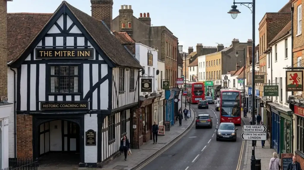
Chipping Barnet sits upon a high ridge along the historic Great North Road, the primary highway connecting London with northern England and Scotland. The term “Chipping” derives from the Old English word ceeping, which translates directly to “market.” King John granted a market charter to the Abbot of St Albans in 1199, establishing a weekly livestock and commodity exchange. This economic foundation expanded exponentially during the seventeenth and eighteenth centuries as long-distance stagecoach travel became the primary method of national transport.
The geographical position of Barnet made it the ideal first major staging post for coaches departing London. At its operational peak in the early nineteenth century, over 150 stagecoaches passed through Chipping Barnet daily. This intense traffic required an extensive infrastructure network to maintain horses and passengers. The town responded by constructing over 30 coaching inns along the High Street, including prominent establishments such as The Mitre, The Red Lion, and The Green Man. These sites provided stable facilities, fresh horses, blacksmithing services, and overnight lodgings.
The wealth generated by the coaching trade altered the municipal topology of the settlement. Brick facades replaced timber-framed Tudor structures, and wealthy merchants erected residential townhouses along the main thoroughfare. The decline of the coaching era began rapidly following the expansion of the Great Northern Railway network in the 1850s. However, the commercial footprint of the Great North Road remains visible in the wide, linear layout of Barnet High Street and the continuous footprint of its historic public houses.
What Are the Architectural Elements of Monken Hadley Church and Its Beacon?
Monken Hadley Church, formally known as the Church of St Mary the Virgin, exhibits classic Perpendicular Gothic architecture, highlighted by its 1494 flint and ironstone tower, which supports a rare, intact medieval iron beacon.
The present structural fabric of Monken Hadley Church dates primarily to its comprehensive reconstruction in 1494, a project heavily funded by local benefactors following the destruction caused by the Battle of Barnet nearby. The building material consists of a distinctive mix of local knapped flint and ironstone rubble, which creates a mottled, durable exterior surface. The building follows a standard medieval layout, featuring a west tower, a nave with north and south aisles, a chancel, and a south porch. The window tracery exhibits the vertical lines and transoms characteristic of the late Perpendicular Gothic style.
The most notable architectural asset of the structure is the square, three-stage western tower. The tower features a prominent octagonal staircase turret on its southwestern corner, which rises above the crenellated parapet. Mounted atop this turret is an original wrought-iron cresset beacon, which is one of only two remaining functional ecclesiastical beacons in the United Kingdom. This iron basket was designed to hold burning pitch or wood to serve a dual purpose as an inland navigational aid and a defensive warning system.
Historically, the Monken Hadley beacon formed a critical node in the nationwide communication chain that linked the south coast of England to the northern counties. During periods of threatened invasion, such as the approach of the Spanish Armada in 1588, these beacons were ignited in sequence to rapidly transmit emergency alerts across vast distances. The interior of the church complements its external historic significance, preserving brass effigies from the fifteenth and sixteenth centuries, alongside structural oak timbers that have survived since the late medieval period.
How Did the Church of St John the Baptist Evolve through the Centuries?
The Church of St John the Baptist evolved from a modest thirteenth-century chapel of ease into an expansive mid-Victorian parish church, significantly altered by a massive architectural expansion overseen by William Butterfield in 1875.
The earliest recorded incarnation of the Church of St John the Baptist was a small chapel built on the site in the mid-thirteenth century under the jurisdiction of the Abbey of St Albans. This structure served the growing population of traders and travelers utilizing the market on the Great North Road. In 1420, the chapel underwent a major reconstruction, which introduced a low nave, a south aisle, and a modest stone tower. Because the church sat directly at the junction of two major highways, its footprint was tightly constrained by the surrounding commercial property lines.
By the mid-nineteenth century, the rapid growth of Barnet’s population rendered the medieval building entirely inadequate for the local congregation. In 1875, the parish commissioned the celebrated High Victorian Gothic revival architect, William Butterfield, to execute a comprehensive expansion. Butterfield chose to retain portions of the 1420 structure, including the original tower and elements of the nave arcade, but he radically altered the building’s axis and scale. He constructed a large new nave, a chancel, and an elevated north aisle that effectively absorbed the ancient chapel into a grander, unified design.
Butterfield’s design is characterized by his restrained use of polychromatic brickwork and stone bands on the exterior, contrasting with a highly detailed interior featuring an ornate reredos and stained-glass windows. The successful blending of the fifteenth-century medieval masonry with nineteenth-century structural engineering created an architectural landmark that commands the highest geographical point of Barnet High Street. To experience this historic landmark in person today, consult our comprehensive [Barnet Visitor Itineraries and Historic Walk Guide] for itineraries and visiting parameters.
Explore More History Of London
How the River Lea Shaped Industrial Heritage and Communities in North London
Hidden Victorian Station Vaults and Underground Arches: North London
What Role Did Queen Elizabeth’s School Play in Barnet’s Educational History?
Queen Elizabeth’s School, founded in 1573 via a royal charter issued by Queen Elizabeth I, established institutional secondary education in Barnet, operating from its original Tudor schoolroom for nearly four centuries.
The establishment of Queen Elizabeth’s School was initiated by a petition from Robert Dudley, Earl of Leicester, who sought to provide a classical grammar school education for the sons of local residents and merchants. Queen Elizabeth I granted the letters patent on 24 March 1573. The initial funding for the construction was raised through local subscriptions and a collection authorized by the Bishop of London. The original school building, known as Tudor Hall, was completed in 1577 on a plot of land adjacent to the Church of St John the Baptist.
The curriculum of the school during its first two centuries focused strictly on the mastery of Latin, Greek, and classical theology, reflecting the standard educational mandates of the Tudor and Stuart eras. The institutional structure was rigid, with students attending classes six days a week under the strict discipline of a Master and an Usher. Tudor Hall itself is a two-story red-brick building featuring large mullioned windows, a clay-tiled roof, and an exposed timber-framed interior. The upper floor originally served as a residence for the schoolmaster, while the ground floor functioned as the single collective schoolroom.
During the English Civil War, the school suffered financial instability and physical disruption, briefly closing its doors as local skirmishes escalated. It recovered during the eighteenth century, undergoing structural repairs and expanding its enrollment base. The school continued to operate within Tudor Hall until 1932, at which point the institution relocated to an expansive modern campus on Queens Road to accommodate contemporary class sizes. Tudor Hall was subsequently restored and stands as one of the oldest surviving intact Tudor educational buildings in Greater London.
Why Is the Wood Street Conservation Area Considered an Architectural Time Capsule?
The Wood Street Conservation Area functions as an architectural time capsule due to its strict preservation of continuous eighteenth- and nineteenth-century domestic facades, institutional buildings, and open civic spaces.
Designated by the municipal authority in 1968 under the Civic Amenities Act 1967, the Wood Street Conservation Area encompasses the historic civic heart of Chipping Barnet. This zone branches westward from the high-density commercial High Street, transitioning into a highly residential and institutional environment. The streetscape is defined by a diverse assortment of architectural styles that reflect the gradual shift from late seventeenth-century timber framing to refined Georgian brickwork and decorative Victorian eclecticism.
A key element of this conservation area is the uniform building line, punctuated by several highly notable individual properties. The area contains excellent examples of Queen Anne and Georgian townhouses, which are identifiable by their symmetrical multi-pane sash windows, prominent stone door cases, and concealed rooflines behind brick parapets. Interspersed among these private residences are significant public assets, such as the Barnet Museum, which occupies an 1820s Georgian house, and the stable blocks of former coaching properties that have been systematically converted for residential use.
The preservation of this district prevents the encroachment of modern commercial developments, ensuring that the original spatial relationships between the domestic buildings, the open common lands of Hadley Green, and the institutional structures remain intact. The strict planning controls enforced within the Wood Street boundaries mandate the use of traditional lime mortars, cast-iron rainwater goods, and timber joinery, thereby preserving the exact material textures of Barnet’s historical apex.
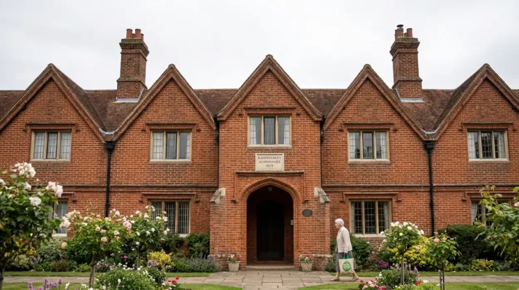
What Is the History of the Ravenscroft Almshouses and How Do They Function Today?
The Ravenscroft Almshouses, constructed in 1679 through a charitable bequest by James Ravenscroft, provided structured sanctuary for destitute local women and continue to operate as active sheltered housing today.
James Ravenscroft, a wealthy local lawyer and major benefactor to the parish of Barnet, established the Ravenscroft Charity via a trust deed to address the acute lack of social welfare for the elderly and impoverished in the seventeenth century. Construction of the almshouses commenced in 1679 on a plot of land situated on the south side of Wood Street. The original building comprised a single, continuous row of six small, one-room brick cottages designed specifically to house six poor, elderly, unmarried women or widows from the Chipping Barnet parish.
The architectural style of the almshouses is exceptionally modest, characterized by plain red-brick masonry, low gabled doorways, and small diamond-paned leaded casement windows. A central stone tablet is set into the front facade, featuring the Ravenscroft coat of arms and a carved inscription that details the date of foundation and the pious intent of the benefactor. The internal layout originally featured open hearths for cooking and heating, with minimal communal amenities located at the rear of the property.
Over the course of three centuries, the internal configuration of the almshouses has undergone multiple modernizing renovations to meet contemporary living standards. The individual rooms were systematically combined and expanded to include modern kitchens, bathrooms, and central heating systems. Despite these internal structural alterations, the exterior street facade remains completely unchanged from its 1679 appearance. The properties continue to be managed by the historic Ravenscroft Trust, fulfilling their original charitable mandate of providing secure, low-cost sheltered housing for local residents.
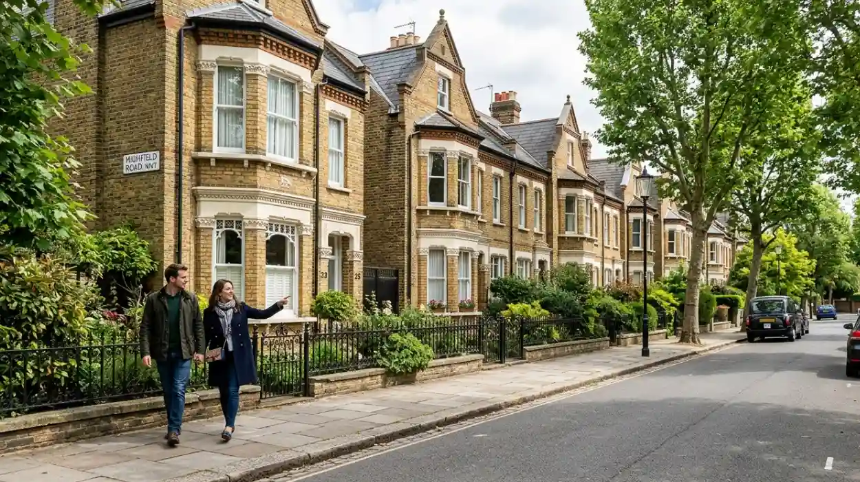
How Did the Arrival of the Railways Transform Barnet’s Landscape and Society?
The opening of High Barnet station in 1872 by the Great Northern Railway terminated the town’s isolation, sparking a rapid housing boom that transformed rural farmland into dense Victorian suburban estates.
Prior to the 1870s, the landscape of Barnet outside the historic core along the Great North Road consisted almost entirely of agricultural fields, hay meadows, and private country estates. The construction of the High Barnet branch line, which connected the district directly to King’s Cross and Moorgate stations in central London, completely altered this rural topology. The railway provided fast, affordable commuting options for middle-class workers, which initiated an immediate and massive inflation in local land values.
Speculative building firms quickly purchased large tracts of agricultural land surrounding the new railway terminus. Estates such as the Ravenscroft Park estate and the Lyonsdown estate were rapidly laid out with gridded road networks to maximize housing density. These developments were filled with substantial detached and semi-detached Victorian villas, which featured fashionable architectural details such as:
- Polychrome brick facades incorporating red and yellow stock bricks
- Intricate decorative plasterwork, ceiling roses, and ornate coving
- Substantial bay windows with stone surrounds and slate roofs
- Tiled front pathways displaying complex geometric patterns
- Carved stone corbels and decorative ridge tiles along the rooflines
This rapid influx of commuting residents caused a shift in the local demographics, transitioning Barnet from an insular, market-driven community into a modern suburban town. The sudden population expansion required a corresponding upgrade in public infrastructure, leading directly to the installation of piped gas networks, main drainage systems, and the construction of new board schools and grand non-conformist chapels throughout the late Victorian period.
What Key Preservation Challenges and Milestones Define Barnet’s Modern Era?
The key preservation milestones in Barnet center on the successful implementation of statutory listings and conservation zones that protect its medieval battlefields and historic buildings from modern commercial development pressures.
Throughout the twentieth century, the relentless expansion of Greater London placed immense developmental pressure on Barnet’s historic assets. The greatest structural threat occurred during the post-war reconstruction boom of the 1950s and 1960s, when many historic high-street structures faced demolition to accommodate modern retail complexes and road-widening schemes. In response to these threats, local historians and residents formed the Barnet Society in 1945, creating an organized lobbying body dedicated to monitoring planning applications and advocating for heritage protection.
A significant preservation milestone was achieved via the Civic Amenities Act 1967, which allowed for the designation of entire areas—rather than just isolated buildings—as protected conservation zones. The rapid creation of the Wood Street and Monken Hadley Conservation Areas provided a robust legal framework to control alterations to the historic fabric. Furthermore, Historic England granted Grade II and Grade II* statutory listed status to critical structures, including Tudor Hall, the Ravenscroft Almshouses, and the Monken Hadley Church, making unauthorized structural alterations a criminal offense.
The preservation of the Battle of Barnet site presented a unique challenge, as the conflict took place across a broad, shifting geographical area. In 1995, English Heritage officially included the Battle of Barnet on the Register of Historic Battlefields, ensuring that any proposed infrastructure or housing development within the tactical boundary must undergo exhaustive archaeological evaluation and impact assessments. These continuous legal and community interventions preserve the physical narrative of Barnet’s past, ensuring its structural and historical integrity survives intact for future generations.
Why is Barnet historically important?
Chipping Barnet developed as a major market town on the historic Great North Road and became famous as the site of the decisive Battle of Barnet.