The statutory infrastructure of Greater London relies on an integrated regional network of high-capacity highways designated as Red Routes, which fall under the exclusive municipal jurisdiction of Transport for London (TfL). Maintaining operational efficacy across this critical network requires the systematic reporting and rectification of surface degradation, such as potholes, and structural asset failures, such as non-functional streetlights. To safeguard public safety, ensure regulatory compliance, and support civic preservation across the capital, citizens and researchers must utilize specific, legally defined reporting mechanisms to initiate municipal maintenance protocols on these state-managed thoroughfares.
- What Are TfL Managed Red Routes And How Did They Evolve Historically?
- Why Is Maintaining Red Route Infrastructure Critical For Public Safety And Civil Preservation?
- How Do I Identify If A Pothole Or Streetlight Falls Under TfL Jurisdiction?
- What Is The Official Step-By-Step Process To Report Maintenance Issues To TfL?
- How Does TfL Prioritise And Rectify Reported Faults Contractually?
- What Long-Term Structural Implications Do Smart City Technologies Have On London’s Highways?
What Are TfL Managed Red Routes And How Did They Evolve Historically?
TfL Managed Red Routes are high-capacity highways in London, denoted by red lines, that prioritize vehicle flow by prohibiting stopping. Developed under the Road Traffic Act 1991, they transitioned to Transport for London jurisdiction following the Greater London Authority Act 1999.
The Post-War Transport Crisis in Greater London
The origin of the contemporary London arterial network stems from systemic congestion challenges that escalated during the mid-to-late twentieth century. Following the termination of World War II, the rapid expansion of private vehicular ownership collided with London’s largely unaltered medieval, Georgian, and Victorian street layouts (Quarshie, 2021). By the late 1980s, arterial routes within the capital suffered from severe vehicular stagnation, which compromised the efficiency of the London Bus network and impeded emergency services (Begg, 2016; Quigley, 2022). Local borough councils executed separate, decentralized parking and traffic management schemes under the Highways Act 1980, which resulted in a fragmented highway network across county boundaries.
The structural lack of a unified, central administrative body to govern inter-borough transit generated significant economic inefficiencies. Commuter corridors were regularly choked by unregulated curbside delivery, illegal double parking, and conflicting municipal traffic orders. National planners recognized that the capital required a distinct, unified category of strategic highways where localized borough interference would be legally restricted in favor of macro-level traffic efficiency.
Legislative Genesis: The Road Traffic Act 1991
To resolve this systemic gridlock, the Parliament of the United Kingdom enacted the Road Traffic Act 1991. This landmark piece of legislation established the statutory framework for “Red Routes”—strategic corridors explicitly designated to maximize traffic throughput, improve air quality, and reduce bus journey times by prohibiting vehicular stopping (Begg, 2016; Quigley, 2022). The implementation phase commenced with a highly monitored $12\text{-mile}$ pilot scheme along the A1 corridor in North London, stretching from Highgate to Commercial Road.
The empirical success of this pilot program, which demonstrated marked reductions in commercial transit durations and a drop in localized casualties, led to the wider rollout of the network. The initiative was initially supervised by the Traffic Director for London, a non-departmental public body created specifically to enforce compliance across individual borough boundaries until a permanent city-wide administrative framework could be devised.
Institutional Consolidation Under the Greater London Authority Act 1999
The contemporary administrative model of the Red Route network materialized through the execution of the Greater London Authority Act 1999 (GLA Act 1999). This legislation re-established a strategic tier of civic governance for the metropolis, creating the Greater London Authority (GLA), the office of the Mayor of London, and the London Assembly (Dixon, 2000; Greer, 2001). Section 254 of the GLA Act 1999 mandated the creation of a functional executive body: Transport for London (Serrano, 2020).
On July 3, 2000, TfL legally absorbed the responsibilities of the Traffic Director for London and assumed direct ownership and operational maintenance of the newly classified Greater London Road Network (GLRN). This network comprises approximately 580 kilometers (360 miles) of the capital’s most critical arterial roadways. While representing less than 5% of the total road length within Greater London, the GLRN carries over 30% of the city’s total vehicular traffic volume.
The visual distinction of these routes was codified via strict road marking regulations. Single red lines denote a conditional prohibition of stopping, subject to specific times displayed on adjacent instructional signage. Double red lines impose an absolute, 24-hour stopping restriction for all non-exempt vehicles, including private automobiles, taxis, and commercial delivery fleets (Quarshie, 2021). To experience the operational reality of this historic transit network in person today, consult our comprehensive [London transport hubs and historic corridors travel guide] for itineraries and visiting parameters.
Why Is Maintaining Red Route Infrastructure Critical For Public Safety And Civil Preservation?
Maintaining Red Route infrastructure prevents catastrophic structural failures, reduces vehicular accidents, and minimizes micro-vibrations that threaten adjacent historical buildings. Robust preservation protocols protect both the physical safety of modern road users and London’s vulnerable architectural heritage.
The Physics and Mechanics of Pothole Degradation
The formation of potholes on heavily trafficked arterials like the Greater London Road Network is driven by a continuous cycle of mechanical stress and moisture intrusion. The process initiates when micro-fissures develop in the wearing course—the top asphalt layer of the road pavement—due to repeated structural loading by heavy goods vehicles (HGVs) and double-decker buses. Rainfall penetrates these superficial fissures, settling into the unbound sub-base layers of the highway.
During the winter months, this trapped water undergoes freeze-thaw cycles. As the water freezes, it expands by approximately 9%, exerting immense localized pressure that fractures the surrounding aggregate matrix. When the ice thaws, it leaves an unsupported subsurface void. Subsequent vehicular loading collapses the unsupported wearing course into the void, rapidly excavating a pothole.
On Red Routes, where average vehicular speeds and traffic volumes are significantly higher than on minor local roads, these depressions present immediate mechanical hazards. They can cause sudden tyre deflation, wheel rim fractures, and abrupt loss of directional control, which poses an acute threat to motorcyclists and cyclists.
Structural Hazards of Broken Street Lighting
Illumination infrastructure along the GLRN serves as a primary structural safeguard for nighttime navigation and pedestrian transit. A breakdown in streetlight continuity alters the spatial awareness of drivers, elongating vehicular braking reaction times. According to road safety engineering metrics, appropriate street lighting reduces nighttime traffic accidents on urban arterials by approximately 30%.
The absence of functional illumination directly obscures pedestrian crossings, structural traffic islands, and roadside debris. Furthermore, because Red Routes serve as primary urban bus corridors, dark transit stops create localized vulnerabilities, increasing the risk of pedestrian slips, trips, and falls near active traffic lanes.
Preservation of Adjacent Architectural Heritage
The implications of deferred Red Route maintenance extend far beyond the kerb, threatening the structural survival of London’s historic built environment. The GLRN intersects directly with numerous Conservation Areas, listed structures, and ancient architectural monuments, ranging from Tudor foundations to Georgian terraces and Victorian brick facades. When heavy commercial vehicles encounter unmitigated potholes or deep road depressions, the impact generates high-amplitude low-frequency ground-borne vibrations.
These micro-vibrations propagate through the surrounding subsoil and transfer directly into the shallow foundations of historic buildings. Over prolonged periods, continuous exposure to these structural waves induces fatigue inside historic masonry, causing lime mortar degradation, structural cracking in external brickwork, and the destabilization of fragile internal plaster ceilings. Regular reporting and rapid intervention prevent these damaging structural waves from compromising London’s fragile architectural history.
How Do I Identify If A Pothole Or Streetlight Falls Under TfL Jurisdiction?
You can identify Transport for London jurisdiction by checking for red road markings, reviewing official municipal boundary maps, or observing the specific asset identification tags attached to the lower columns of streetlighting infrastructure.
Visual Indicators: Red Lines and Signage
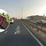
The primary method to determine if an infrastructure defect falls under regional rather than local municipal management is the presence of red statutory road markings. If a pothole is located on a lane bordered by a single or double solid red line painted along the edge of the carriageway, the road is part of the Greater London Road Network and is managed directly by Transport for London.
Additionally, roadside signage along these routes features unique red borders and white lettering detailing stopping exemptions, a design choice distinct from the blue or yellow regulatory signs used by individual London Boroughs. If the defect is located on a standard single or double yellow line, or within an unmarked street, jurisdiction reverts to the local borough council (e.g., the London Borough of Camden or the City of Westminster).
Spatial Anomalies: The Core Bridges and Inner Ring Road
While the red line system is a reliable baseline, specific critical thoroughfares across the capital lack red paint but remain under the absolute statutory ownership of TfL. These exceptions comprise the majority of London’s historic river crossings and major junctions. TfL retains exclusive maintenance responsibility for the structural decks, road surfaces, and illumination systems of several major bridges, including:
- Westminster Bridge
- Blackfriars Bridge
- Tower Bridge (excluding the internal lifting mechanisms, which are operated by the City of London Corporation)
- Vauxhall Bridge
Portions of the London Inner Ring Road also fall under TfL’s remit despite varying visual markings. When reporting a fault near these historic structures, you must check the exact spatial coordinates against the official statutory maps hosted on the Greater London Authority portal to ensure accurate routing.
Asset Tags on Streetlighting Columns
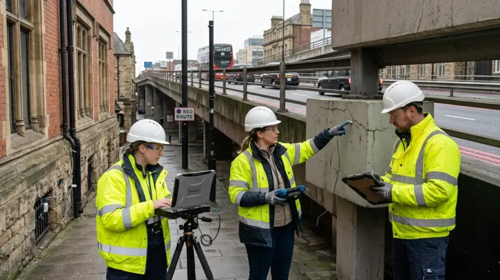
To verify jurisdiction over a non-functional streetlight, look for the identification plates mounted on the vertical support columns. Streetlights under the management of Transport for London feature distinct asset tags. These tags typically display a unique alphanumeric code paired with an explicit TfL logo or a prefix specifically designated for the strategic road network (e.g., “TFL-GLRN-XXXX”).
Local borough streetlights, by contrast, carry the crest or name of the respective local council. Collecting this specific alphanumeric code prior to submitting a report ensures that municipal engineers can locate the precise asset instantly within the regional geographic information system (GIS) database.
Explore More Public Services
Evolution of Resident Parking Permits and Traffic Management in London
Council Housing Application Document Requirements in Greater London
What Is The Official Step-By-Step Process To Report Maintenance Issues To TfL?
Reporting maintenance issues to TfL requires identifying the precise asset type, logging the exact location via the digital Highway Report tool, uploading photographic evidence, and submitting the entry to trigger automated municipal engineer dispatch.
Navigating the Digital Highway Report Tool
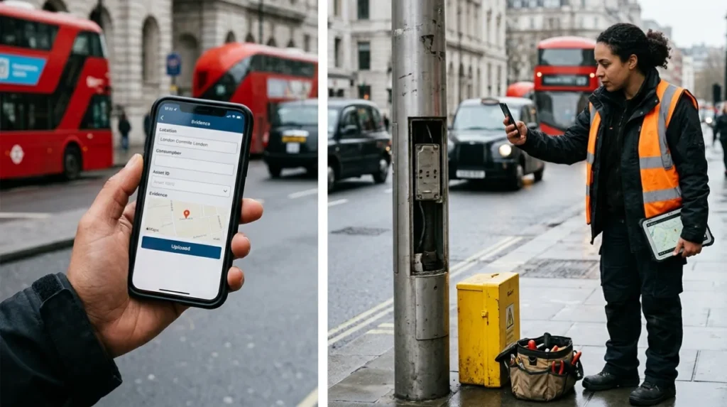
Transport for London operates a centralized digital reporting portal designed specifically to capture asset failures across the Greater London Road Network. This platform is optimized for both desktop and mobile web browsers, allowing for rapid field data entry by citizens and researchers. The system interfaces directly with TfL’s central asset management database, bypassing manual sorting desks to streamline processing speeds.
1.Access the Portal and Select Asset Classification:Step 1: Classification.
Open the official TfL Street Care reporting portal. Select the specific category of infrastructure failure from the primary menu: choose “Roads and Pavements” for potholes, or “Streetlighting and Signs” for illumination failures.
2.Pinpoint Geographic Location via Geospatial Mapping:Step 2: Geolocation.
Utilize the interactive GIS map interface to drop a digital pin on the exact location of the defect. Enter a postcode or street name to zoom into the area, then manually adjust the marker directly over the specific lane or kerb space where the pothole or broken streetlight resides.
3.Input Asset Specifications and Structural Data:Step 3: Detail Input.
Provide descriptive details. For potholes, estimate the approximate width and depth (e.g., greater than 40mm). For streetlighting, input the alphanumeric asset identification code copied from the base of the column, and state whether the lamp is completely unlit, flickering, or physically damaged.
4.Upload Photographic Verification and Submit:Step 4: Evidence & Dispatch.
Attach up to three clear photographs showing the defect from both a close-up angle and a wider contextual perspective. Enter your contact details to receive automated tracking updates, then click submit to log the issue into the municipal maintenance queue.
Emergency Reporting Protocols for Acute Hazards
The digital portal is strictly designated for non-critical, routine maintenance tracking. If an infrastructure failure poses an immediate, life-threatening risk to the public, you must bypass the online form and utilize the dedicated 24-hour telephone helpline. Acute hazards include:
- Deep potholes on high-speed sections of the GLRN (e.g., the A40 or A2) that force vehicles to swerve into adjacent lanes.
- Completely collapsed streetlighting columns blocking pedestrian walkways or active carriage lanes.
- Exposed electrical wiring protruding from damaged streetlight inspection panels.
In these specific scenarios, citizens must call 0343 222 1234 (charged at standard network rates). This direct line connects straight to the TfL Network Management Control Centre, which has the statutory authority to immediately deploy emergency response teams, adjust regional traffic signal timings, or initiate temporary road closures to protect public safety.
How Does TfL Prioritise And Rectify Reported Faults Contractually?
TfL prioritizes defects using a risk-based matrix that measures safety implications against traffic volume. Contracted highway maintenance providers must repair critical Category 1 hazards within 2 to 24 hours of formal validation.
The Risk-Based Asset Management Framework
Once a report is submitted, TfL engineers classify the defect using a structured risk-assessment framework. This matrix evaluates two core metrics: the severity of the structural defect and the specific operational characteristics of the roadway. A pothole measuring over $40\text{mm}$ in depth on a high-speed arterial route receives an elevated risk rating compared to a similar depression within a designated parking bay.
Similarly, a single dark streetlight at a high-risk pedestrian crossing or major roundabout is prioritized over an unlit bulb on a straight, well-lit stretch of highway. This systemic classification ensures that municipal resources are directed toward hazards that present the greatest risk to public safety.
Contractual Response Windows and Service Level Agreements
TfL executes its physical maintenance operations through localized Highway Maintenance and Project Frameworks (HMPF). These contracts split Greater London into specific geographic zones (e.g., North, South, East, and West), with private civil engineering consortiums serving as the delivery partners. These contracts contain strict, legally binding Service Level Agreements (SLAs) that dictate the maximum permissible time from fault validation to physical on-site repair.
Permanent Engineering Interventions vs. Temporary Measures
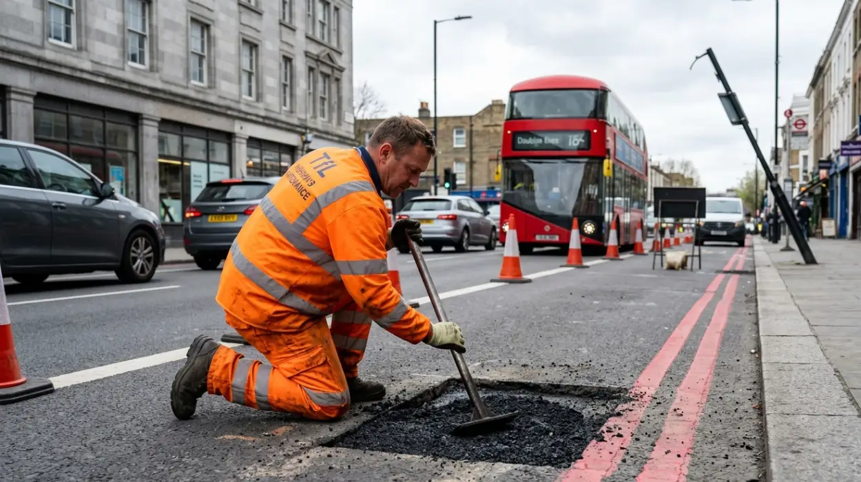
When an engineering crew is dispatched to an urgent Category 1 pothole, initial structural constraints may dictate a temporary patch using cold-lay asphalt macadam. This rapid intervention stabilizes the surface immediately, preventing further aggregate unraveling and mitigating the short-term safety risk.
However, these temporary measures are contractually required to be replaced by permanent engineering repairs within a designated timeframe. A permanent repair involves saw-cutting a clean geometric rectangle around the damaged area, excavating the compromised asphalt base layers, treating the vertical edges with a hot bituminous emulsion seal to prevent future water ingress, and backfilling the cavity with hot-rolled asphalt (HRA) compacted to matching density metrics.
What Long-Term Structural Implications Do Smart City Technologies Have On London’s Highways?
Smart City technologies shift highway maintenance from a reactive model to an automated, predictive paradigm. Integrated Internet of Things (IoT) sensors and mobile digital scanning arrays optimize regional resource allocation while preserving historical urban infrastructure.
Automated Defect Detection via Intelligent Mobility Networks
The integration of digital sensor arrays into modern urban transit networks has fundamentally transformed how municipal authorities identify infrastructure decay. Instead of relying solely on manual citizen reports, modern asset management systems leverage automated computer-vision algorithms mounted to municipal fleets and public transport vehicles.
As London buses travel along their designated routes, high-definition optical sensors continuously scan the surface of the pavement (Begg, 2016; Quigley, 2022). These devices use real-time LiDAR (Light Detection and Ranging) and spatial imagery to map the precise topography of the road.
When the system detects surface deformations or anomalies that match the structural signature of a developing pothole, it logs the exact geospatial coordinates automatically within the central TfL database. This predictive tracking allows engineers to intervene during the early stages of asphalt cracking, long before the structural integrity of the wearing course collapses entirely.
Smart Streetlighting and Central Management Systems
The modern lighting infrastructure along the Greater London Road Network is steadily transitioning to an intelligent, interconnected network governed by a Central Management System (CMS). Contemporary luminaire units are outfitted with wireless IoT communication nodes mounted directly onto individual LED lamp heads. These nodes continuously monitor electrical power consumption, voltage stability, and lamp functionality.
If an LED driver fails or a bulb burns out, the unit sends an automated alert containing its exact asset tag directly to the maintenance contractor’s dispatch terminal. This eliminates the traditional delay associated with waiting for manual night-scouting crews or pedestrian notifications, dramatically accelerating repair turnarounds for critical transit routes.
Long-Term Benefits for Urban Heritage and Public Investment
The long-term benefits of these smart innovations extend across fiscal, structural, and cultural dimensions. By utilizing automated predictive maintenance, TfL can transition from a costly, reactive model to a highly targeted prevention strategy. Repairing a minor surface fissure costs significantly less than excavating a deep, collapsed pothole or replacing a degraded sub-base layer (Sloman, 2013).
From a preservation perspective, addressing road roughness before it shifts into advanced degradation drastically lowers the amplitude of ground-borne traffic vibrations. This proactive maintenance minimizes the structural fatigue inflicted on London’s nearby historic architectures, ensuring the capital’s unique material heritage survives alongside its evolving modern transport infrastructure.
What is a TfL-managed Red Route?
A TfL-managed Red Route is a strategic road in Greater London marked by single or double red lines. These roads are managed by Transport for London (TfL) to keep traffic moving and generally prohibit stopping except where specifically permitted.