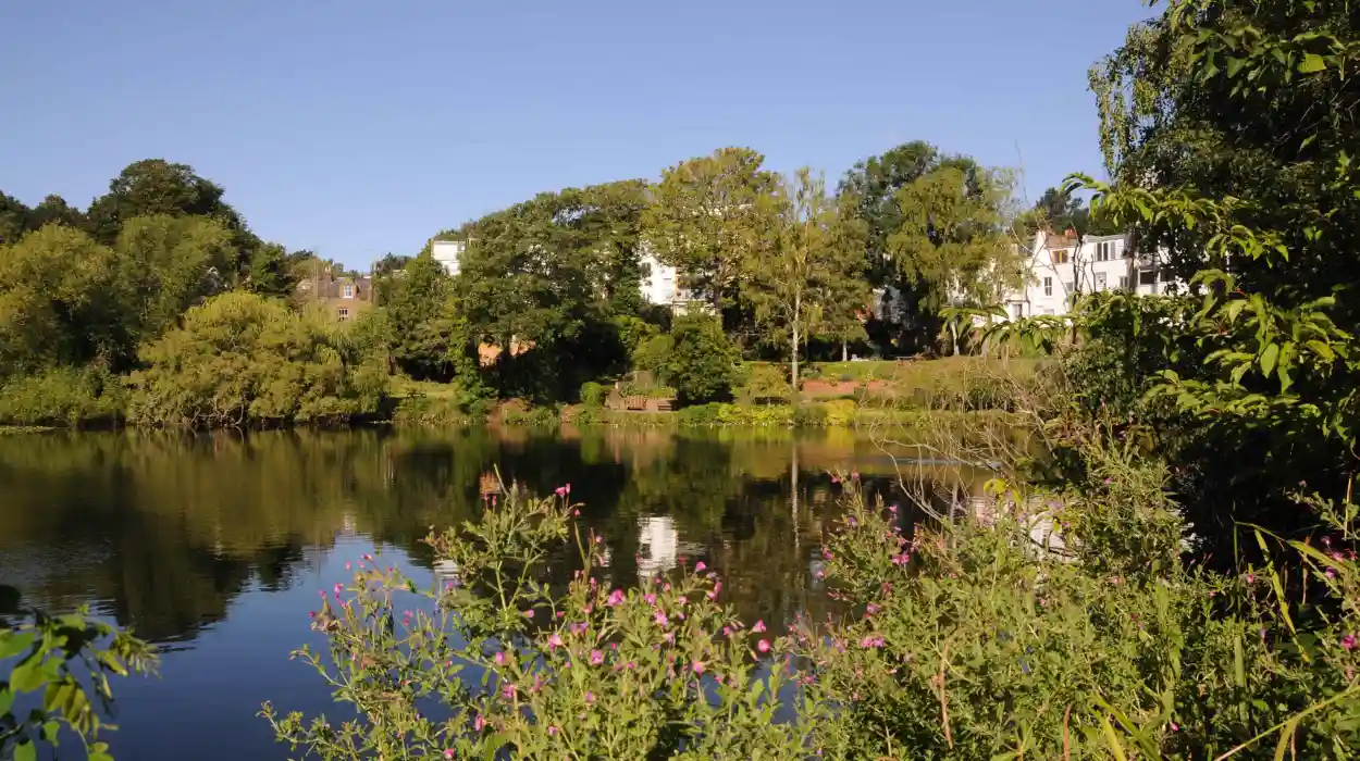
Hampstead is one of London’s most historically distinctive landscapes, combining ancient heathland, preserved woodland, designed Georgian estates, secluded gardens and elevated viewpoints above the modern capital. Its hidden walking spots reveal how centuries of geography, landownership, conservation and urban expansion shaped northern London.
- Why is Hampstead one of London’s best areas for peaceful walks and historic views?
- What makes Parliament Hill the most important panoramic viewpoint in Hampstead?
- Where can visitors find Hampstead’s oldest surviving historical boundaries?
- Why is Kenwood one of Hampstead’s most important historic walking landscapes?
- What is the Hill Garden and Pergola, and why does it feel hidden?
- Why is the Vale of Health important to Hampstead’s history?
- What makes Whitestone Pond a significant historic viewpoint?
- How did Hampstead Heath survive London’s urban expansion?
- Which hidden routes best connect Hampstead’s history with panoramic views?
- Why do Hampstead’s views remain historically important today?
- What does Hampstead’s hidden landscape reveal about London’s future heritage?
- Why should visitors explore Hampstead beyond its famous landmarks?
- Frequently Asked Question
The area is especially significant because Hampstead developed on high ground while London expanded across the surrounding lowlands. This geography created long-distance views, protected open spaces and a network of paths that still connect medieval boundaries, eighteenth-century estates and Victorian conservation landscapes.
The best hidden spots in Hampstead are therefore more than quiet places to walk. They are surviving historical landscapes. A route through the area can pass archaeological evidence from the Anglo-Saxon period, former manorial boundaries, Georgian gardens, nineteenth-century public preservation campaigns and protected views of the twenty-first-century skyline.
Historic England identifies Hampstead as an Archaeological Priority Area containing evidence ranging from prehistoric finds to the medieval settlement. The first documented reference to the Hampstead manor dates to AD 986, when King Æthelred II granted it to the monastery of St Peter at Westminster.
For visitors seeking peaceful walks and panoramic city views, the most important locations include Parliament Hill, the Vale of Health, Kenwood, the Hill Garden and Pergola, the Saxon Ditch, Whitestone Pond and quieter woodland routes across Hampstead Heath.
Why is Hampstead one of London’s best areas for peaceful walks and historic views?
Hampstead combines elevated terrain, ancient heathland, protected public open space and historic estates, creating peaceful walking routes with exceptional views. Its landscape preserves evidence from prehistoric occupation, Anglo-Saxon boundaries, medieval settlement, Georgian design and nineteenth-century conservation across northern London.
Hampstead occupies some of the highest ground in Greater London. Its topography explains both its historical development and its continuing importance as a walking destination.
Before extensive urban development, the area consisted largely of open heathland on elevated sandy ground. Historic England records archaeological evidence of prehistoric activity across Hampstead and Hampstead Heath, including Palaeolithic and Mesolithic flint tools. Roman evidence has also been identified in the wider historic settlement area.
The medieval settlement developed around the Hampstead manor and the routes that later became the village streets. The name Hampstead derives from the Anglo-Saxon term associated with a homestead or manor settlement. By the time of the Domesday Book in 1086, the locality was recorded as a small rural community with agricultural land and woodland.
The relationship between village and heath remained central to Hampstead’s identity. The settlement grew, but the surrounding open land retained unusual historical importance. During the nineteenth century, development pressure threatened parts of the Heath. Public campaigns and legal protection helped preserve large areas as open land rather than allowing continuous urban construction.
That preservation created the modern landscape. Hampstead contains streets and buildings, but extensive routes still cross woodland, meadows, ponds and hillsides.
The area also provides a physical record of different historical periods. A single walk can connect:
- prehistoric archaeological landscapes, including flint-find locations;
- Anglo-Saxon boundaries, including the Saxon Ditch;
- medieval settlement patterns around Hampstead village;
- Georgian landscapes, including Kenwood;
- nineteenth-century conservation campaigns protecting the Heath.
These examples demonstrate why Hampstead remains historically valuable as well as visually distinctive.
To experience the wider landscape in person today, consult our comprehensive [Insert Anchor Text for Things to Do Article Here] for itineraries and visiting parameters.
What makes Parliament Hill the most important panoramic viewpoint in Hampstead?
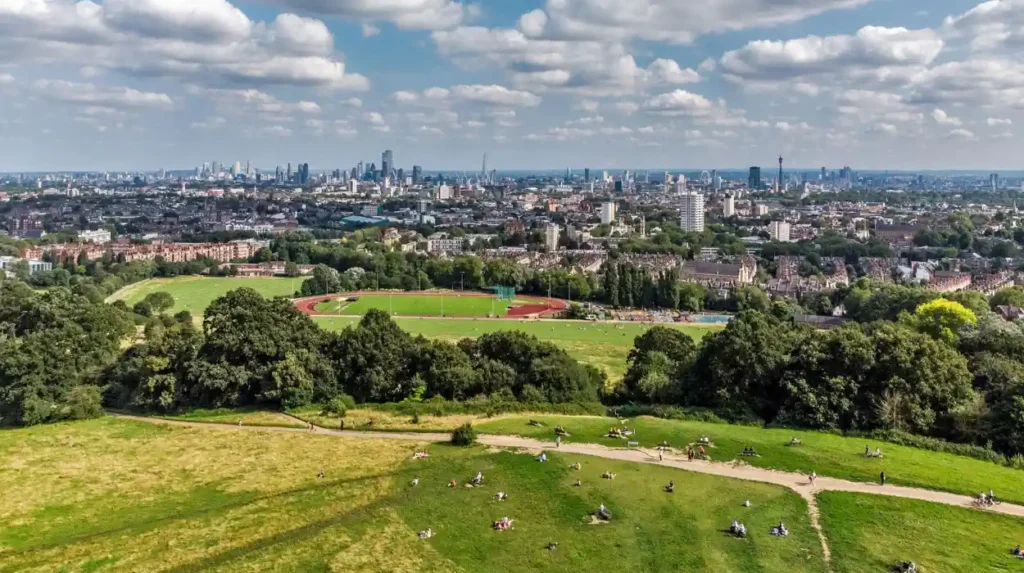
Parliament Hill is Hampstead Heath’s most prominent public viewpoint, rising approximately 98 metres above sea level and providing protected panoramic views across London. Its elevated position, historical associations and conservation status make it a central destination for walkers and landscape historians.
Parliament Hill stands in the southeastern part of Hampstead Heath and is one of the capital’s best-known natural viewpoints.
The City of London identifies the summit as approximately 98 metres, or 321 feet, above sea level. From the viewpoint, the London skyline includes major landmarks such as St Paul’s Cathedral, the Palace of Westminster, The Shard and the Gherkin.
The importance of Parliament Hill comes from its geography. London developed extensively across the Thames basin, while Hampstead Heath remained on higher ground to the north. This elevation created a visual relationship between open countryside and the expanding city.
The hill’s name has several historical explanations and traditions. The City of London notes associations with the seventeenth-century English Civil War and Parliamentarian activity, while other traditions connect the name with the visibility of Parliament from the elevated ground. The official walking material also records historical uncertainty surrounding the name.
The landscape became increasingly important during the nineteenth century as London expanded rapidly. Preserving high ground was not simply an environmental issue. It also protected public access to open views and prevented the complete enclosure of a historically significant landscape.
Parliament Hill was incorporated into Hampstead Heath in 1888. Its panoramic outlook remains protected as part of London’s system of significant views.
The site therefore represents two connected historical developments. First, it preserves an ancient natural landscape within a major city. Second, it demonstrates how Victorian and later conservation policies recognised the public value of open views.
For a peaceful walk, the surrounding slopes provide quieter alternatives to remaining directly on the summit. Paths through Parliament Hill Fields connect open grassland with the ponds and wooded areas of the central Heath.
The best historical approach is to treat Parliament Hill as part of a larger landscape rather than as an isolated viewpoint.
Where can visitors find Hampstead’s oldest surviving historical boundaries?
The Saxon Ditch provides one of Hampstead Heath’s clearest surviving connections to early medieval land organisation. Dating to at least AD 986 according to the City of London, it marks an ancient manorial and parish boundary preserved within the woodland landscape.
The Saxon Ditch is one of the most historically important hidden features on Hampstead Heath.
Unlike Parliament Hill, it does not dominate the landscape through height or architecture. Its importance lies in its function as a surviving boundary.
The City of London describes the ditch as probably the oldest man-made structure on the Heath and states that it has existed since at least AD 986. Ancient trees and stones also mark the historic manorial and parish boundary.
The date is significant because AD 986 also belongs to the earliest documented history of the Hampstead manor. Historic England records the grant of the manor to the monastery of St Peter at Westminster during the reign of King Æthelred II.
Medieval and Anglo-Saxon landscapes were organised through boundaries. Ditches, banks, hedges and natural features established ownership, agricultural responsibility and administrative divisions.
The Saxon Ditch therefore provides evidence of how land was structured long before modern roads and borough boundaries existed.
For historians and genealogical researchers, these surviving boundaries provide important context. Families living in Hampstead and neighbouring settlements were shaped by parish jurisdictions, manorial systems and patterns of landholding. A boundary was an administrative structure with direct consequences for taxation, inheritance, agriculture and local identity.
The surrounding woodland also demonstrates why quiet walking routes can preserve important archaeology. Not every historic site takes the form of a monument or building. Some of the most valuable historical evidence survives as subtle changes in ground level and landscape organisation.
Why is Kenwood one of Hampstead’s most important historic walking landscapes?
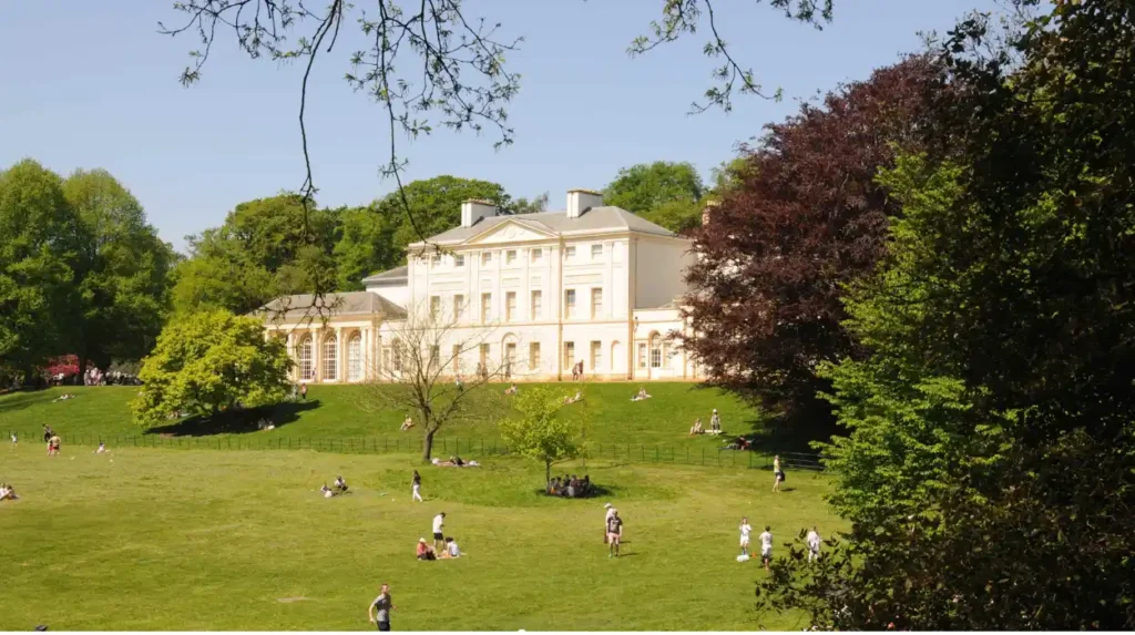
Kenwood combines a Grade I listed historic house, eighteenth-century architecture and a designed landscape of woodland, lakes and meandering paths. Its estate preserves the transformation of a seventeenth-century house into a major Georgian cultural landscape overlooking Hampstead Heath.
Kenwood occupies the northern edge of Hampstead Heath and provides one of the strongest examples of how architecture and landscape design shaped the area.
The first house on the site was probably established in the early seventeenth century. English Heritage records that John Bill, printer to King James I, purchased the estate in 1616.
The estate changed dramatically during the eighteenth century.
William Murray, the 1st Earl of Mansfield, commissioned the Scottish architect Robert Adam to transform the house. Between 1764 and 1779, Adam developed Kenwood into a major neoclassical residence with highly significant interiors.
Robert Adam was one of Britain’s most influential eighteenth-century architects. His work at Kenwood demonstrates the architectural culture of the Georgian elite, when country houses combined domestic accommodation, artistic display and carefully designed landscapes.
The estate itself also became part of the architectural experience.
Humphry Repton, a major landscape designer of the late eighteenth and early nineteenth centuries, remodelled parts of the grounds. English Heritage records that Repton created meandering paths and used groves of trees to structure views through the landscape.
This is important for modern walkers because the paths were designed to control movement and visual experience. A route through Kenwood is therefore not simply a convenient modern footpath. It reflects historical landscape planning.
Historic England describes the registered landscape as approximately 45 hectares and records important surviving features including the lakes, Dairy, woodland routes and Sham Bridge.
How does the Kenwood landscape create peaceful walking routes?
Kenwood’s landscape combines open lawns with enclosed woodland. This creates a sequence of changing environments within a relatively compact historic estate.
The southern terrace historically provided extensive views across London. Tree growth has altered some of those sightlines, but the relationship between elevated parkland and the wider city remains fundamental to the site’s design.
English Heritage describes approximately 112 acres of parkland with ancient woodland, designed gardens and walking paths.
The contrast between open meadow and dense trees makes Kenwood particularly suitable for visitors seeking quieter routes.
Why is the Sham Bridge historically significant?
The Sham Bridge is an eighteenth-century landscape feature associated with Robert Adam.
Historic England describes it as a three-span timber façade designed to create the visual illusion that water continued beyond the structure. This reflects the sophisticated use of perspective within Georgian landscape design.
The bridge demonstrates an important principle of historic landscape architecture: views were deliberately constructed.
Natural scenery and architectural intervention worked together. Trees framed sightlines. Paths controlled movement. Water reflected buildings and vegetation.
Kenwood therefore provides evidence of the social and cultural priorities of eighteenth-century Britain while remaining part of the modern public landscape.
What is the Hill Garden and Pergola, and why does it feel hidden?
The Hill Garden and Pergola preserve an early twentieth-century landscape associated with The Hill, later Inverforth House. Designed and expanded through the work of Thomas H. Mawson, the site contains terraces, formal garden spaces and elevated architectural walkways overlooking Hampstead’s wooded landscape.
The Hill Garden and Pergola provide a different historical experience from the open terrain of Parliament Hill.
This landscape is enclosed, architectural and deliberately structured.
Historic England records that Hill House existed by the nineteenth century and was extensively remodelled after Sir William Hesketh Lever, later Lord Leverhulme, purchased the property in 1904. The estate became known as The Hill.
The gardens developed during a period when wealthy private estates increasingly used formal architecture to organise outdoor space.
Thomas H. Mawson was an important landscape architect and designer associated with the redevelopment of the gardens. Historic England describes the landscape as an early nineteenth-century garden redesigned in the early twentieth century, including colonnaded pergolas extending across further garden areas.
The Pergola creates a distinctive walking environment. Its long elevated structure, climbing vegetation and sequence of columns separate it from the more open landscapes of Hampstead Heath.
The historical importance of the site lies in its survival as a designed private landscape that later became publicly accessible.
Its secluded character also explains its appeal. The Pergola is physically close to the Heath but feels architecturally separate from it.
The Hill Garden demonstrates another layer of Hampstead’s history: the transformation of private elite estates into preserved public heritage.
Why is the Vale of Health important to Hampstead’s history?
The Vale of Health preserves evidence of Hampstead Heath’s changing relationship with landownership, recreation and development. Its secluded location records nineteenth-century attempts to reshape the Heath while demonstrating how public resistance and conservation protected major areas from urban construction.
The Vale of Health is one of the quieter settlements within the Hampstead Heath landscape.
Its historical significance comes partly from its isolation. The settlement developed within a landscape that remained difficult to reconcile with continuous urban expansion.
Historical walking material records that Sir Thomas Maryon Wilson, who held manorial rights over parts of the Heath, constructed an estate road in 1845 as part of wider plans connected with development. Public opposition ultimately prevented the large-scale building programme from transforming the Heath.
This conflict represents a major theme in Hampstead history.
Nineteenth-century London required housing, infrastructure and commercial development. At the same time, public health reformers and conservation campaigners increasingly argued for the preservation of open land.
Hampstead Heath became a major example of this struggle.
The Vale of Health therefore represents the tension between private land rights and public access.
For modern walkers, its quiet roads and surrounding vegetation provide a visible reminder that the current landscape was not inevitable. Without successful preservation campaigns, large areas of the Heath would have followed the dense development patterns visible elsewhere in London.
The survival of this environment has long-term historical significance because it preserves the relationship between settlement and open countryside within a modern metropolis.
What makes Whitestone Pond a significant historic viewpoint?
Whitestone Pond occupies elevated ground near Hampstead village and forms part of the historic high-level landscape above London. Its location connects village history, public open space and long-distance views, demonstrating why Hampstead’s topography became central to conservation and recreation.
Whitestone Pond sits near one of the highest and most historically prominent parts of Hampstead.
The surrounding elevated landscape has long provided views across London and towards areas beyond the capital.
Historic England records that Hampstead’s war memorial occupies a prominent location at approximately 134.5 metres above Ordnance Datum, reflecting the exceptional height of the surrounding area.
This elevation influenced Hampstead’s historical identity.
The area offered cleaner air and physical separation from the densely built city below. From the medieval period onward, Hampstead’s position helped establish its reputation as a place outside the immediate urban core.
The high ground also became strategically and symbolically important during the First World War.
Historic England records military recruitment meetings, patriotic speeches and training activities on the Heath. Local units used the landscape for drills and exercises.
Whitestone Pond and its surrounding routes therefore connect scenic walking with the military and civic history of the borough.
The location also provides an important transition between Hampstead village and the Heath.
A historical walk can begin among the dense streets and buildings of the old settlement before reaching open water, trees and distant views within a short distance.
How did Hampstead Heath survive London’s urban expansion?
Hampstead Heath survived because public campaigns, legal action, institutional management and land acquisition protected major areas from private development. Nineteenth-century conservation transformed the Heath into a permanent public landscape and established an important model for preserving metropolitan open space.
The preservation of Hampstead Heath is one of the most important historical processes behind the modern landscape.
London’s population expanded dramatically during the nineteenth century. Land surrounding the city increased in commercial value, and former rural estates faced strong pressure for housing development.
The Heath was vulnerable because much of the land remained under complex patterns of ownership and manorial rights.
Local residents, campaigners and public institutions challenged proposals that threatened access to the landscape.
The preservation movement reflected broader Victorian concerns about public health and urban living. Open spaces were increasingly understood as essential infrastructure rather than unused land.
The eventual protection of the Heath preserved woodland, grassland, ponds and elevated viewpoints for public use.
Parliament Hill became part of Hampstead Heath in 1888.
Kenwood followed a different route into public preservation. Historic England records that the Kenwood Preservation Trust secured parts of the estate, while Lord Iveagh purchased the house and remaining grounds in 1924 and bequeathed them to the nation after his death in 1927. The grounds were formally transferred to public trusteeship in 1928.
These developments created the connected landscape visible today.
Public preservation involved several forms of historical change, including:
- land acquisition, such as the transfer of private estates into public ownership;
- legal protection, such as restrictions preserving open landscapes;
- institutional management, including long-term stewardship of public spaces.
These examples explain why Hampstead retains extensive natural and historic land despite being surrounded by one of the world’s largest urban areas.
Which hidden routes best connect Hampstead’s history with panoramic views?
The strongest historical walking routes connect Parliament Hill, the ponds, the Saxon Ditch, Vale of Health, Kenwood and elevated village viewpoints. These landscapes create a continuous route through ancient boundaries, preserved heathland, designed Georgian parkland and protected views across London.
The most informative way to explore Hampstead is through connected landscapes rather than isolated attractions.
A route beginning around Parliament Hill introduces the broad relationship between elevation and the London skyline. The City of London identifies the viewpoint as one of the key places for understanding the Heath’s panoramic geography.
Walking northward through quieter paths introduces the Heath’s ecological and historical complexity.
The Saxon Ditch provides evidence of early medieval land organisation.
The ponds demonstrate the importance of water management and landscape engineering within the Heath.
The Vale of Health introduces the nineteenth-century conflict between development and conservation.
Kenwood then presents the eighteenth-century transformation of private land into a designed cultural landscape. Robert Adam’s architecture and Humphry Repton’s landscape work demonstrate how elite estates shaped the visual experience of the countryside.
The Hill Garden and Pergola provide evidence of early twentieth-century garden design and the architectural ambitions of private estates.
This sequence creates a clear historical timeline across physical space.
The route moves through:
- early settlement landscapes, including Anglo-Saxon boundaries;
- Georgian estates, including Kenwood;
- nineteenth-century preservation, including the public protection of the Heath;
- twentieth-century heritage landscapes, including the Pergola and Hill Garden.
These examples demonstrate how a peaceful walk through Hampstead also functions as a chronological exploration of London’s history.
Why do Hampstead’s views remain historically important today?
Hampstead’s views remain historically important because they preserve the visual relationship between protected open land and London’s changing skyline. These sightlines connect historic churches, nineteenth-century monuments and modern towers while demonstrating the continuing importance of landscape conservation within a growing capital.
A panoramic view is a historical resource.
From Hampstead’s elevated ground, the skyline provides evidence of different phases of London’s development.
Older landmarks such as St Paul’s Cathedral represent the rebuilding of London after the Great Fire of 1666. The Palace of Westminster represents nineteenth-century Gothic Revival architecture and parliamentary government. Modern towers represent later commercial and technological development.
Parliament Hill allows these periods to be viewed within a single urban panorama.
The City of London specifically identifies major landmarks visible from the viewpoint, including St Paul’s Cathedral, The Shard, the Gherkin and the Palace of Westminster.
The preservation of these views therefore has cultural significance beyond tourism.
A protected sightline maintains the ability to understand London geographically.
It demonstrates where historic buildings stand within the wider city and how modern construction has altered the skyline.
This relationship is especially important for educators and students studying urban development.
A map explains distance. A panoramic viewpoint demonstrates it physically.
For heritage researchers, the views also show why Hampstead’s high ground became so valuable. Elevation provided separation from the city while maintaining visual contact with it.
That relationship remains the defining feature of the area.
What does Hampstead’s hidden landscape reveal about London’s future heritage?
Hampstead demonstrates that historic preservation includes landscapes, views, paths, boundaries and ecological systems alongside buildings. Its future heritage value depends on maintaining public access, archaeological evidence, historic sightlines and the relationship between open countryside and London’s continuing urban development.
Hampstead’s historical importance extends beyond individual monuments.
The area demonstrates that heritage exists across an entire landscape.
The Saxon Ditch is heritage because it records an early boundary. Parliament Hill is heritage because it preserves a historically significant public view. Kenwood is heritage because architecture, art and landscape design survive together. The Vale of Health is heritage because it records the outcome of a struggle over development.
These places require different forms of protection.
Buildings need conservation and repair. Archaeological features require careful management. Views require planning controls. Woodlands require ecological stewardship.
The future significance of Hampstead will therefore depend on maintaining connections between these elements.
The landscape also provides a practical lesson for London.
Historic preservation does not require freezing a city in time. London continues to change. New buildings, infrastructure and communities reshape the capital.
Hampstead demonstrates that change and preservation can exist together when historically significant landscapes receive long-term protection.
Its peaceful paths remain valuable because they provide continuity.
A walker can still move through terrain that preserves traces of the Anglo-Saxon period, medieval land organisation, Georgian estate planning, Victorian conservation and twentieth-century heritage design.
That continuity is increasingly rare in major global cities.
Why should visitors explore Hampstead beyond its famous landmarks?
Exploring Hampstead beyond its famous landmarks reveals a layered historical landscape where quiet paths, ancient boundaries, designed gardens and elevated viewpoints explain London’s development. The hidden locations provide direct access to the geography, conservation history and cultural heritage that shaped the district.
The best hidden spots in Hampstead are connected by history.
Parliament Hill explains the importance of elevation and protected views. The Saxon Ditch preserves evidence of early medieval boundaries. Kenwood records the architecture and landscape design of the Georgian period. The Vale of Health demonstrates the struggle between development and conservation. The Hill Garden and Pergola preserve the ambitions of an early twentieth-century private estate.
Together, these places create a historical landscape rather than a collection of separate attractions.
For history enthusiasts, they provide physical evidence of changing land use.
For cultural tourists, they offer quieter routes beyond the busiest London landmarks.
For educators and students, they provide direct examples of archaeology, architecture, conservation and urban geography.
For heritage preservationists, they demonstrate the importance of protecting landscapes as complete systems.
For genealogical researchers, the surviving parish boundaries, settlement patterns and historic routes provide essential context for understanding how generations of Hampstead residents lived within the landscape.
Hampstead remains exceptional because its history is still visible underfoot.
Its paths cross boundaries established centuries ago. Its hills preserve views across a city that has transformed repeatedly. Its estates have moved from private ownership into public heritage. Its open land survived the expansion of modern London.
That combination makes Hampstead one of the capital’s most important destinations for peaceful historical walks and panoramic city views.
Frequently Asked Question
Is Parliament Hill part of Hampstead Heath?
Yes. Parliament Hill is part of Hampstead Heath, the large historic open space managed by the City of London. Parliament Hill became part of Hampstead Heath in 1888 and is protected for its landscape and views.