Key Points
- Elite Ranking: Richmond Park’s full outer loop has been officially ranked as one of the top ten most scenic running routes in the United Kingdom.
- National Survey: The ranking stems from a comprehensive survey of 2,000 UK runners commissioned by the Postcode Lottery to find the nation’s most visually impressive trails.
- Voter Breakdown: The expansive south London park secured 18 per cent of the total vote, tying for fifth place nationally alongside Edinburgh’s iconic Arthur’s Seat loop.
- Urban Exception: Alongside the Hyde Park to Kensington Gardens route, Richmond Park was one of only two London settings to break into the top ten, defying traditional rural dominance.
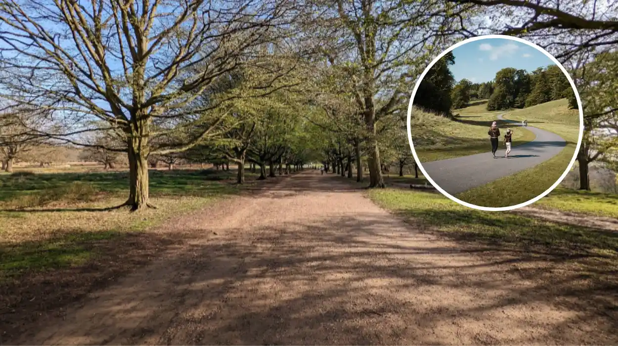
- Natural Attributes: The 12-kilometre (approximately 7.35-mile) perimeter trail, widely known as the Tamsin Trail, won acclaim for its distinctive blend of roaming deer herds, ancient oaks, and panoramic viewpoints.
- New Digital Campaign: The announcement coincides with the launch of the Postcode Lottery’s “Crowns for Causes” Strava challenge, a summer fitness initiative aimed at raising £5 million for charitable organizations.
London (The Londoner News) June 13, 2026 – A historic Royal Park in south London, celebrated for its ancient woodlands and roaming herds of wild deer, has been formally recognized as one of the most scenic running destinations in the United Kingdom. Richmond Park’s full outer perimeter loop secured a coveted position within the top ten most visually impressive running routes nationwide following an expansive public survey commissioned by the Postcode Lottery. The study, which evaluated the views of 2,000 active runners across the country, tasked participants with rating various paths based on their landscape quality, aesthetic appeal, and overall structural running experience.
- Key Points
- Which Position Did Richmond Park Secure in the National Scenic Rankings?
- What Makes the Richmond Park Outer Loop Distinctive for Runners?
- How Long is the Richmond Park Perimeter Route and What is the Terrain Profile?
- Why are Modern Runners Increasingly Drawn to Visually Impressive Environments?
- How Does This Survey Link to the New ‘Crowns for Causes’ Charity Initiative?
- What Key Rules and Safety Measures Should Runners Follow Inside Richmond Park?
- Are There Extension Routes Available for Long-Distance Training?
Garnering 18 per cent of the total votes, the expansive south-west London reserve finished alongside Edinburgh’s Arthur’s Seat summit loop, marking a significant victory for urban green spaces against more traditional, remote countryside trails. The findings highlight Richmond Park’s unique position as a National Nature Reserve located within London’s Zone 6, offering city dwellers an accessible, multi-terrain escape that seamlessly replicates the rural British countryside.
The recognition arrives amidst a shifting landscape for recreational athletics, where physical environments are increasingly evaluated for both mental well-being and digital appeal. The Postcode Lottery survey also tracked contemporary behavioral trends among British joggers, revealing that modern running routes are increasingly treated as visual assets for social validation. According to the published data, nearly half of all respondents admitted to feeling tangible pressure to ensure their outdoor workouts look sufficiently impressive before uploading them to athletic tracking networks.
Which Position Did Richmond Park Secure in the National Scenic Rankings?
As reported by journalist Andy Devaney of Sustain Health Magazine, the Postcode Lottery study placed Richmond Park firmly within the upper echelon of British running routes, earning 18 per cent of the vote to share the fifth tier of the national table. The comprehensive poll was topped by Scotland’s Loch Lomond Shores to Ben Lomond trail, a grueling 13-kilometre Highland route that captured 22 per cent of the vote due to its dramatic mountain theater.
Writing for Sustain Health Magazine, Devaney noted that the national poll favored routes that elevate exercise into an immersive natural experience:
“The Loch Lomond route may have topped the poll, but the list as a whole is the real story. Britain’s runners are choosing places that make effort feel worthwhile: lochs, parks, piers, forests, coast paths and city summits.”
The competitive landscape of the top ten highlights the prestige of Richmond Park’s inclusion. The inner-city route from Hyde Park to Kensington Gardens claimed the second spot nationally with 21 per cent, tying with the Ambleside to Grasmere trail in the Lake District. Northern Ireland’s Giant’s Causeway coastal trail followed closely with 20 per cent, just ahead of Richmond Park and Arthur’s Seat.
Explore More South London News
Gail’s Bakery to Open Controversial New Brixton Store: London 2026
UAL Launches Free Public Art Exhibitions and Performances: South London 2026
What Makes the Richmond Park Outer Loop Distinctive for Runners?
According to a regional analytical report published by London Now, Richmond Park offers a distinct “countryside feel” that is highly unusual for a location accessible via central London’s public transport network. Spanning an impressive 955 hectares, it stands as the largest of London’s eight Royal Parks, providing an expansive environment of open grasslands, quiet woodland paths, and wide spaces that are exceptionally rare within the capital.
An unsigned editorial contributor for London Now detailed the specific structural allure of the trail, stating that the route features
“a mix of open grasslands, ancient oak trees and roaming herds of deer, with both flat and gently undulating terrain for runners.”
The physical route essentially follows the park’s perimeter, offering an multi-terrain surface that shifts from hard-packed sandy paths to stony trail sections.
Key Landscape Landmarks Along the Route
- Isabella Plantation: A enclosed woodland garden running along the southern sections of the loop, famed for its intense seasonal color displays and vibrant spring azaleas.
- Pen Ponds: A pair of large, historic lakes situated in the center of the parklands, providing runners with expansive waterfront views and a tranquil mid-run setting.
- King Henry’s Mound: A historic high point offering an uninterrupted, legally protected view that stretches across London directly to the distant dome of St Paul’s Cathedral.
How Long is the Richmond Park Perimeter Route and What is the Terrain Profile?
According to technical route guides provided by the specialist athletic platform River Thames Running, Richmond Park is widely viewed as the premier long-distance training ground in south London due to its expansive, undulating geography. The primary route utilized by long-distance runners is the Tamsin Trail, a purpose-built, shared-use perimeter path that loops around the edge of the park boundary.
As outlined by the editorial team at River Thames Running, the circuit is highly regarded because it is
“quite hilly and undulating so it is the perfect place to do your long runs.”
The path spans roughly 11.7 kilometers (7.3 miles) and features approximately 80 meters of elevation gain across a full lap.
Why are Modern Runners Increasingly Drawn to Visually Impressive Environments?
The underlying motivations driving British runners toward scenic environments extend beyond basic cardiovascular fitness, revealing a significant cultural shift toward digital documentation. As detailed by Andy Devaney of Sustain Health Magazine, the Postcode Lottery research identified a direct connection between natural beauty and social media habits. The study confirmed that 49 per cent of contemporary runners feel acute pressure to make their workouts appear visually impressive once uploaded online to platforms like Strava or Instagram.
Commenting on this behavioral trend, Devaney observed that
“the modern run is no longer just a private negotiation between legs, lungs and poor life choices. It is also content.”
This digital reward system has transformed scenic trails like the Tamsin Trail into valuable social currency, where landscape photography and verified elevation maps form an integral part of the modern athletic subculture.
Beyond the social aspect, structural running experts emphasize that scenic environments serve as an effective psychological distraction from physical exhaustion. The changing vistas of Richmond Park—moving from dense ancient oak woods to expansive views of the River Thames from Richmond Hill—help mitigate the mental fatigue associated with repetitive, long-distance workouts.
How Does This Survey Link to the New ‘Crowns for Causes’ Charity Initiative?
The publication of the national scenic running data directly coincides with a major charitable fundraising campaign launched across the United Kingdom. As reported in the Sustain Health Magazine investigative coverage, the Postcode Lottery has officially partnered with the digital athletic network Strava to launch a summer fitness challenge titled “Crowns for Causes.”
The corporate initiative seeks to leverage the massive scale of the UK’s outdoor running community to unlock an estimated £5 million in funding for various charitable causes. The digital challenge invites everyday runners across the country to log a series of three distinct outdoor activities via the Strava platform over the summer months.
By tying the campaign to the country’s most beautiful landscapes, organizers hope to maximize participation rates, driving runners to locations like Richmond Park to fulfill their fitness goals while supporting wider philanthropic efforts. The initiative reinforces a growing trend within the British charity sector to use digital athletic gamification to secure corporate donations for non-profit organizations.
What Key Rules and Safety Measures Should Runners Follow Inside Richmond Park?
While the perimeter route offers an exceptional running experience, its status as a National Nature Reserve and a protected habitat brings specific operational constraints. According to safety notices compiled by the community resource platform Richmond Park London, runners must remain mindful of the park’s highly sensitive ecosystem, particularly its centuries-old animal populations.
The platform’s safety guide notes that runners can move freely across almost all areas of the park, but warns individuals to “watch out for the deer resting in the ferns in late summer and early autumn!” The park is home to over 600 free-roaming red and fallow deer, and official guidelines from the Royal Parks agency mandate that visitors maintain a minimum distance of 50 meters from the animals at all times to prevent defensive behavior.
Furthermore, route analysts at Richmond Park London note that while the Tamsin Trail is the most popular path, it is a shared-use trail accommodating walkers, cyclists, and family groups. For advanced runners seeking uninterrupted speed work or tempo training, experts recommend utilizing the quiet, car-free internal roads that cut through the center of the park, which offer a smooth, predictable asphalt surface away from pedestrian congestion.
Are There Extension Routes Available for Long-Distance Training?
For endurance athletes looking to extend their training sessions beyond the standard 11.7-kilometre outer loop, the geography of south-west London provides unique opportunities for route expansion. As documented by the international trail mapping directory Great Runs, Richmond Park serves as a central hub within a much larger network of interconnected public green spaces.
The cartographic team at Great Runs highlighted that the park’s eastern boundary directly touches another major wilderness area, creating an ideal layout for half-marathon or marathon distance training:
“On its eastern edge, it touches another park, Wimbledon Common, meaning you can easily extend your runs eastwards… The Common is one of South West London’s largest green spaces, with 1,100 acres to explore.”
By exiting via the Robin Hood Gate on the eastern side of the Tamsin Trail, runners can cross directly into Wimbledon Common, adding a network of rugged, unpaved woodland trails and historic features like the Wimbledon Windmill. Additionally, the route can be linked westward toward Bushy Park or southward along the towpaths of the River Thames, providing long-distance runners with an expansive, traffic-free training matrix unmatched anywhere else in Greater London.