The Londoner News presents an authoritative review of the comprehensive modifications implemented across the transit infrastructure of West London in 2026. Urban transportation networks are changing rapidly as municipal authorities balance the competing demands of commercial viability, carbon reduction legislation, and commuter transit efficiency. The strategic reconfiguration of public space within the Royal Borough of Kensington and Chelsea, the London Borough of Hounslow, and the London Borough of Ealing marks a decisive shift toward active travel modalities. Active travel is defined as physical human-powered locomotion, primarily walking, wheeling, and cycling, used as an alternative to motorized vehicular transport.
- What Is The Current State Of West London Cycling Infrastructure?
- How Do New Pedestrian Zones Change Commuter Traffic Flow?
- What Challenges Do Local Businesses Face With Pedestrian Updates?
- How Are Commute Times Impacted By West London Route Shifts?
- What Environmental Changes Result From Active Travel Upgrades?
- How Do West London Residents View These Transit Policy Shifts?
This transformation aligns with the statutory frameworks of the United Kingdom Department for Transport (DfT) Decarbonising Transport Strategy and the network management duty guidance issued under the Traffic Management Act 2004. These legislative pillars mandate local authorities to allocate greater road capacity to pedestrians and cyclists to mitigate greenhouse gas emissions and lower systemic congestion.
This guide details the structural components, operational mechanisms, and public reception of the newly deployed Cycleways and pedestrian environments across the West London sectors. By examining specific arteries, including the expansion of Cycleway 9 (C9) and the pedestrian adjustments along major high streets, this report serves as a definitive resource for commuters navigating the modern logistical landscape of the capital.
What Is The Current State Of West London Cycling Infrastructure?
The structural network consists of segregated cycle corridors designed to insulate non-motorized users from vehicular traffic through physical barriers, dedicated lane markings, and specialized traffic signaling arrays. These corridors connect suburban peripheries directly to central London financial and commercial districts.
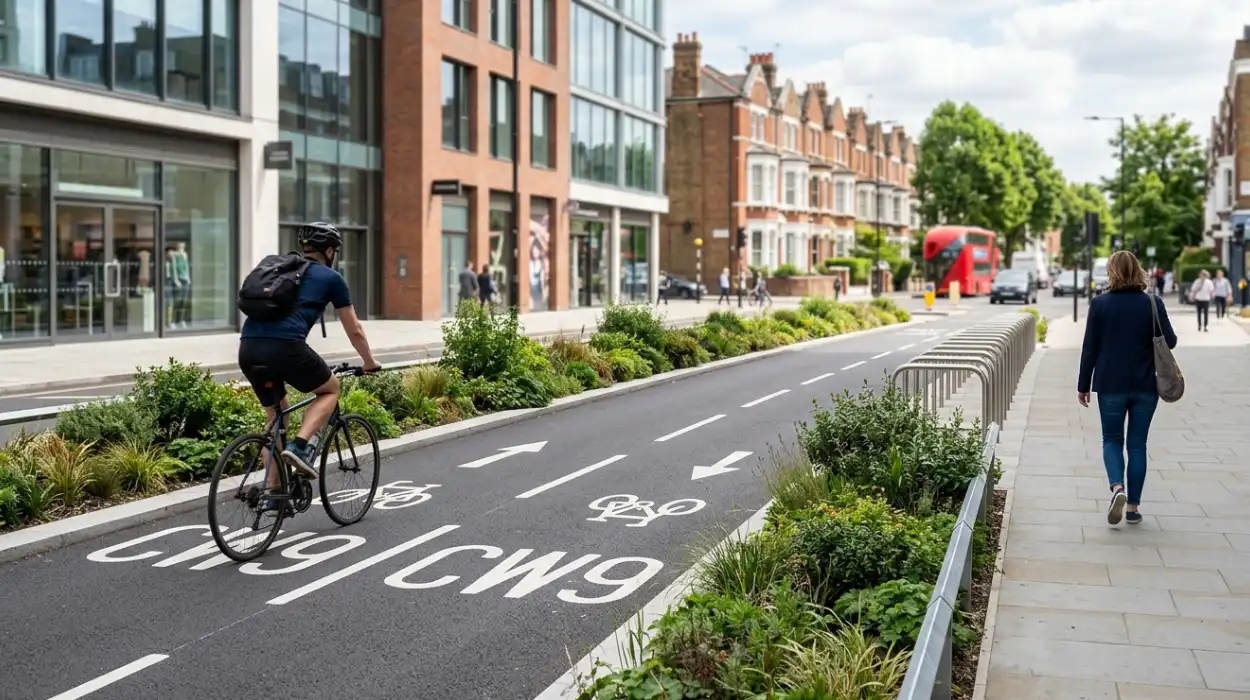
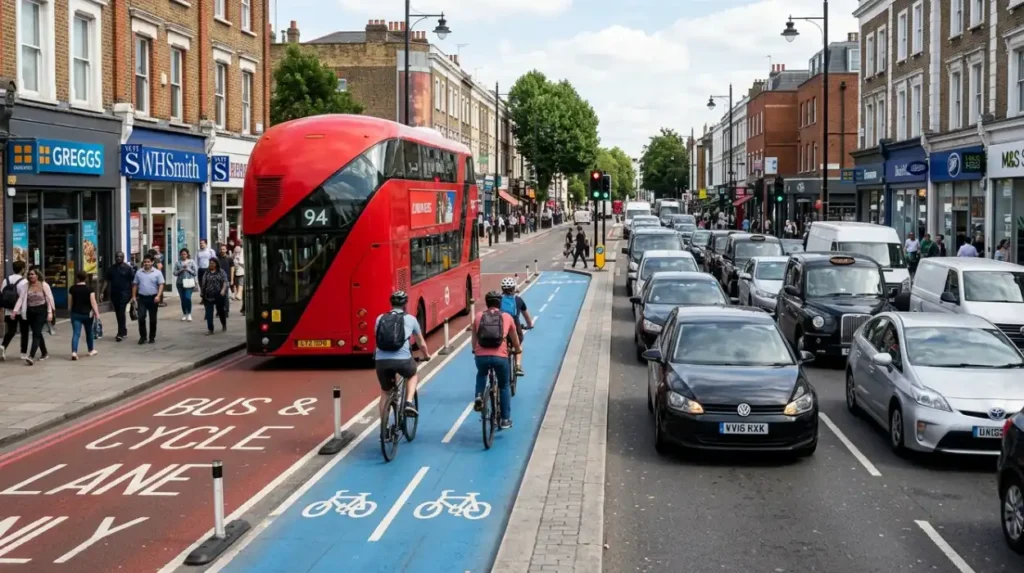
The contemporary cycling infrastructure of West London operates under a re-engineered classification system mandated by Transport for London (TfL), transitioning historical designations like “Cycle Superhighways” into a unified “Cycleway” network. In 2026, the primary backbone of this infrastructure is Cycleway 9 (C9), a major strategic route extending from Brentford through Chiswick High Road toward Hammersmith and Kensington. The physical architecture of this corridor features clear lane segregation, utilizing raised concrete medians, rubber curbs, and vertical plastic bollards to eliminate lateral conflicts between cyclists and motor vehicles (Rein-Sapir, 2025). The standard width of these tracks is fixed at a minimum of 1.5 to 2.5 meters for unidirectional paths, ensuring adequate spatial capacity for diverse cycle configurations (Bhuyan et al., 2020; Larkin, 2026).
The material design incorporates a specialized slip-resistant blue polyurethane surfacing. This colored surface serves as an immediate visual differentiator to prevent accidental pedestrian incursions and to warn motorists at intersecting junctions. The primary operational objective of the network is to handle utility journeys. Utility journeys are trips made for specific daily purposes such as workplace commuting, educational transit, or retail shopping, as opposed to recreational or leisure cycling without a fixed destination.
To preserve the throughput of the network during heavy usage periods, the infrastructure incorporates advanced traffic control measures. Bicycle Traffic Signal Coordination, or “Green Wave” signaling, is deployed across successive intersections where the physical distance between junctions drops below 400 meters (Grigoropoulos et al., 2021). The operational mechanism utilizes optical sensors and inductive loop detectors embedded in the asphalt to track arriving clusters of cyclists. The signal controller then alters phase timings, advancing the cycle green phase by approximately 5 seconds ahead of parallel motor vehicle phases to dissolve standing queues and prevent dangerous blind-spot collisions with turning vehicles.
The spatial footprint of the network caters to 3 primary categories of non-motorized vehicles, which include standard bi-wheeled commuter bicycles, adapted tricycles for users with mobility impairments, and commercial cargo e-bikes handling final-mile logistics. By formalizing this spatial allocation, TfL seeks to accelerate modal shift, converting short-distance private vehicular trips into active travel journeys.
How Do New Pedestrian Zones Change Commuter Traffic Flow?
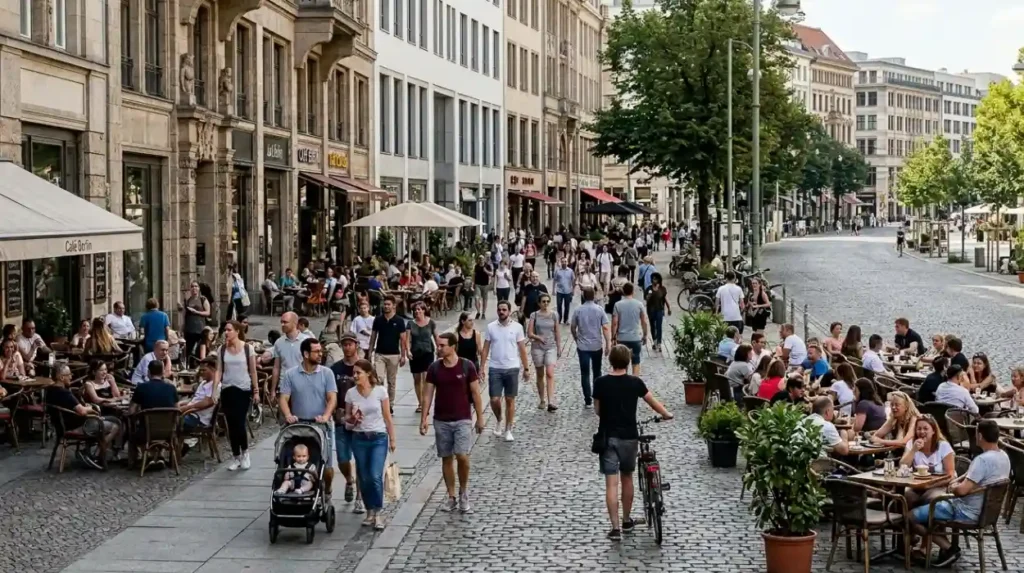
Pedestrian zones reconfigure traffic flow by introducing partial or absolute vehicular restrictions on targeted high streets, shifting motorized traffic to peripheral trunk roads. This spatial reallocation lengthens vehicular transit times while increasing pedestrian safety, sidewalk capacity, and active travel safety.
The implementation of expanded pedestrian zones across West London high streets relies on Low Traffic Neighbourhood (LTN) frameworks and Liveable Neighbourhood funding allocations provided by TfL (Jones, 2026). These zones are designed to alter the urban microclimate and mitigate localized air pollution by intentionally reducing the volume of internal combustion engines within dense retail and residential environments (Ma, 2026). The geometric reorganization of these streets involves widening pedestrian footways, converting staggered pedestrian crossings into direct single-stage paths, and installing systematic tactile paving arrays for visually impaired users (Bosetti, 2022).
The macro-level mechanism of a pedestrian zone functions through the strategic placement of physical and virtual modal filters. Modal filters are street design interventions that permit the passage of pedestrians, cyclists, and emergency service vehicles while preventing entry by general motorized traffic. In West London, these filters take 3 primary structural forms, which include fixed steel bollards that physically block vehicular passage, planters that introduce green infrastructure into the roadway, and automatic number plate recognition (ANPR) cameras that issue financial penalties to non-permitted vehicles entering restricted sectors.
The relocation of motorized traffic from high street cores onto surrounding strategic roads, such as the A4 and A40 corridors, causes a localized rebalancing of transit velocities. Within the pedestrianized zones, the speed limit is lowered to 15 miles per hour to minimize kinetic energy differentials between different road users (Bosetti, 2022). Consequently, commuter traffic flow becomes bifurcated: private motor vehicles experience marginal increases in journey durations along peripheral routes, whereas multi-modal commuters utilizing London Underground stations, London Buses, and active walking pathways experience reduced transit friction within the high street centers.
What Challenges Do Local Businesses Face With Pedestrian Updates?
Local businesses face supply chain disruptions, reduced curbside loading access for delivery fleets, and initial drops in customer footfall from automobile-dependent demographics. These structural challenges require companies to alter their logistical strategies and adapt to micromobility-based consumer patterns.
The conversion of standard vehicular roadways into pedestrianized areas and segregated cycle tracks removes conventional curbside parking spaces and delivery bays, directly impacting the operations of brick-and-mortar retailers. On major high streets, such as Chiswick High Road and Kensington High Street, retail businesses rely heavily on constant supply chains to maintain inventory levels. The installation of continuous cycle track boundaries creates a physical barrier that prevents commercial vans from parking directly outside storefronts, forcing delivery drivers to park in distant designated bays and transport goods manually over longer distances.
The corporate impact of these alterations is unevenly distributed across 3 distinct business categories, which include independent retail boutiques, high-volume hospitality venues, and specialty service providers like medical or legal practices. Independent boutiques often experience a drop in patronage from affluent suburban consumers who prefer the convenience of private automobile transit for carrying large purchases (Rein-Sapir, 2025). Conversely, hospitality venues often benefit from the expanded pavement space, which allows for outdoor seating and increases spontaneous footfall from pedestrians.
To maintain supply chain integrity, businesses must adapt to the growing micromobility logistics ecosystem. Micromobility refers to light, low-speed vehicles operating at speeds below 15 miles per hour, including e-scooters, electric bicycles, and specialized commercial cargo bikes (Bosetti, 2022). Commercial distribution companies are increasingly utilizing centralized consolidation hubs located on the fringes of West London. Heavy freight vehicles unload shipments at these hubs, and fleet operators transfer the goods onto electric cargo tricycles capable of navigating pedestrianized corridors and restricted cycle lanes without violating local traffic regulations.
Explore More Things To Do
Merton Abbey Mills Markets and Local Infrastructure Projects: Colliers Wood
Proposed Residential Developments and Green Belt Planning News in Esher
How Are Commute Times Impacted By West London Route Shifts?
Commute times show divergent results: journey durations for private motor vehicles increase due to reduced lane capacity, while transit times for cyclists and bus passengers decrease. These changes occur because segregated routes provide uninterrupted paths that bypass typical urban gridlock.
The re-allocation of road space to accommodate the expansion of Cycleway 9 and pedestrian zones reduces the total width available for motorized vehicles, often cutting multi-lane configurations down to single lanes. This reduction in spatial capacity for cars causes a temporary decrease in average vehicular speeds during peak morning and evening commuting hours. According to causal traffic modeling frameworks applied to London transit data, the introduction of restricted cycling infrastructure creates localized congestion on non-restricted parallel roads, as the same volume of private automobiles is compressed into fewer available lanes (Bhuyan et al., 2020).
The impact on total travel time depends on the specific mode of transport chosen by the commuter. The system influences travel durations across 3 distinct commuter categories, which include private automobile operators, bus passengers, and active cycle commuters. Private automobile operators experience an expansion in overall trip durations, particularly during peak hours, as bottlenecks form at major intersections where turning movements are restricted. Bus passengers experience more variable impacts; while buses can encounter delays at shared bottlenecks, the integration of dedicated bus lanes with cycleway barriers can insulate public transit from general traffic queues.
For cycle commuters, travel times become highly predictable and substantially lower over short-to-medium distances up to 10 kilometers. Because the segregated infrastructure isolates cyclists from the friction of motor vehicle queues, individuals maintain a stable average velocity between 10 and 25 kilometers per hour (Grigoropoulos et al., 2021). The elimination of stop-and-start cycles at non-coordinated intersections allows cyclists to complete cross-borough journeys faster than private cars during peak periods, illustrating the efficiency gains achieved through dedicated spatial isolation.
What Environmental Changes Result From Active Travel Upgrades?
Active travel upgrades lower tailpipe greenhouse gas emissions, decrease localized nitrogen dioxide levels, and reduce urban heat island effects. These improvements are achieved by lowering total motor vehicle mileage and adding green spaces along pedestrian paths.
The environmental profile of West London boroughs is closely linked to the volume of fossil fuel combustion within the regional transport network. Urban transport systems act as primary contributors to atmospheric degradation, releasing carbon dioxide ($CO_2$), fine particulate matter ($PM_{2.5}$), and nitrogen oxides ($NO_x$) into the dense boundary layer of the city (Ma, 2026). The strategic goal of the 2026 active travel expansions is to meet the UK government’s statutory commitment to achieve net-zero greenhouse gas emissions by 2050 (Jones, 2026). By building infrastructure that encourages walking and cycling, municipal planners seek to reduce the overall vehicle kilometers traveled (VKT) across the capital.
The environmental transition operates across 3 main ecological categories, which include ambient air quality, acoustic pollution levels, and microclimate temperature regulation. Ambient air quality shows a measurable drop in particulate concentrations within pedestrianized zones where internal combustion engines are restricted. Acoustic pollution is similarly mitigated; the substitution of multi-ton passenger vehicles with light micromobility alternatives lowers the baseline ambient decibel levels on residential and retail streets, improving the overall quality of the urban environment.
Microclimate temperature regulation is advanced through the integration of sustainable drainage systems (SuDS) and pocket parks within the expanded pedestrian zones. Motorized vehicles release direct anthropogenic waste heat from their engines and braking systems, elevating local air temperatures (Ma, 2026). Replacing asphalt surfaces with permeable paving and vegetation helps cool the surrounding air through evapotranspiration and mitigates localized flash flooding by absorbing rainwater runoff. This combination of emissions reduction and green infrastructure installation directly enhances the long-term climate resilience of West London’s urban core.
How Do West London Residents View These Transit Policy Shifts?
Resident opinions remain deeply divided between active travel advocates who praise the safety improvements and automobile-reliant citizens who oppose the loss of road space. This friction highlights a broader conflict between city-wide sustainability goals and local community needs.
The introduction of Cycleway 9 and accompanying pedestrian zone updates has generated significant public debate within West London communities, particularly across the Chiswick and Kensington sectors. Public consultations managed by TfL and local councils reveal a stark division in values and daily transit habits among the population (Rein-Sapir, 2025). Proponents of the infrastructure emphasize the safety benefits, noting that segregated paths open active travel options to vulnerable demographics, including school children, elderly citizens, and individuals using mobility scooters.
The sociological divergence is evident across 3 specific resident demographics, which include multi-generational families with high domestic transport needs, younger urban professionals utilizing active transit options, and local business owners managing physical shops. Multi-generational families frequently voice objections, stating that the elimination of vehicular lanes complicates essential multi-stop journeys, such as transporting children with heavy equipment or carrying large grocery purchases (Rein-Sapir, 2025). These residents often perceive active travel mandates as an intrusive policy shift that ignores the practical realities of car-dependent lifestyles.
This friction is further amplified by how public consultations are handled. Many residents express skepticism regarding the validity of online engagement platforms and remote workshops, arguing that local feedback is often secondary to broader, city-wide transport targets set by the Mayor of London (Rein-Sapir, 2025). This tension between localized inconvenience and macro-level environmental planning remains a central challenge for transport planners working to build long-term public support for active travel systems across the capital.
What is Cycleway 9 (C9)?
Cycleway 9 is a major segregated cycling corridor connecting Brentford, Chiswick, Hammersmith, and parts of inner West London. It forms part of the wider London Cycleway network managed by Transport for London.