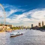
London’s South Bank is the riverside district on the southern side of the River Thames, principally within Lambeth and extending east toward Bankside and Blackfriars. Today it is associated with the Southbank Centre, National Theatre, BFI Southbank, County Hall, museums, public spaces and pedestrian routes. Its present cultural identity developed from a much older landscape shaped by marshland, river transport, manufacturing, railways, government, wartime destruction and post-war reconstruction.
- What was London’s South Bank like before industrialisation?
- When did South Bank become an industrial waterfront?
- How did bridges and railways transform the South Bank?
- Which industries shaped South Bank during the nineteenth century?
- Why was the Thames Embankment important to South Bank’s development?
- How did County Hall change the South Bank?
- How did the First World War and interwar period affect South Bank?
- How did the Second World War change South Bank?
- Why was the Festival of Britain important to South Bank?
- How did the Royal Festival Hall establish South Bank as a cultural quarter?
- How did the National Theatre expand South Bank’s cultural identity?
- What other cultural institutions became important on South Bank?
- Which historic structures still reveal South Bank’s industrial past?
- How has South Bank been preserved as a historic cultural landscape?
- What does South Bank’s history reveal about London’s wider development?
- Frequently Asked Question
The history of London’s South Bank is therefore a history of repeated land-use change. The waterfront moved from low-lying marsh and gardens to industrial yards, from industrial production to bomb-damaged land, and from damaged industrial ground to a major cultural destination. Each transformation left physical evidence in the surviving buildings, roads, bridges, embankments and architectural landmarks.
What was London’s South Bank like before industrialisation?
Before industrialisation, South Bank was a low-lying Thames-side landscape containing marshy ground, gardens, fields, pleasure grounds and scattered settlement, with the river controlling transport, flooding, land use and economic activity along the southern edge of central London.
The southern bank of the Thames developed differently from the north bank because much of the land was low lying and vulnerable to flooding. Lambeth’s riverside remained comparatively difficult to build on for long periods. The river itself shaped the physical geography by depositing mud and creating a shallow foreshore.
The area also stood outside the administrative control of the City of London. This distinction encouraged activities that faced restrictions within the City. Entertainment developed alongside agriculture and river-related commerce. Cuper’s Garden, a pleasure garden operating between 1691 and 1759, occupied land close to the present Waterloo Road area. Pleasure gardens were commercial leisure spaces combining gardens, entertainment and public sociability.
The river remained the most important geographical feature. Before modern roads and railways, water transport provided an efficient method for moving heavy materials. Timber, coal, building materials and manufactured goods could travel by barge along the Thames.
This early geography explains why later industrial development concentrated beside the river. The waterfront provided access to transport, while inexpensive and reclaimed land created space for yards, warehouses and factories.
When did South Bank become an industrial waterfront?
South Bank became an established industrial waterfront during the seventeenth and eighteenth centuries, when timber yards, wharves and manufacturing occupied the river edge; by 1740, timber wharves and yards already lined substantial stretches of the southern Thames waterfront.
Lambeth Council’s South Bank Conservation Area Statement records industrial development beginning in the seventeenth century. By 1740, timber wharves and yards occupied large plots along the Narrow Wall. These sites connected manufacturing directly with the Thames.
Industrial expansion accelerated during the eighteenth century. The river supplied transport for raw materials and finished products. Businesses requiring large quantities of bulky materials therefore benefited from waterfront locations.
One important manufacturer was Eleanor Coade’s artificial-stone works. Coade stone was a highly durable ceramic material used for architectural decoration and building components. The factory operated in Lambeth and became an important part of London’s eighteenth- and nineteenth-century manufacturing landscape.
The South Bank also contained timber yards, builders’ yards, sawmills, lime kilns and other industrial premises. Historical evidence shows that the area around the future County Hall site contained builders’ yards, a timber yard and a flour mill during the nineteenth century.
The waterfront was not simply an industrial zone. Housing, workshops, roads, gardens and entertainment existed alongside production. This mixed land use created a densely occupied working environment.
Industrial activity expanded because London itself was expanding. The capital required enormous quantities of construction materials, food, fuel and manufactured goods. The South Bank’s position beside the Thames made it an effective distribution and production zone.
How did bridges and railways transform the South Bank?
Bridges and railways transformed South Bank by connecting the riverside directly with central London and national transport networks; Westminster Bridge, Waterloo Bridge, Waterloo Station, Hungerford Bridge and railway infrastructure progressively changed movement, land values and development patterns.
Westminster Bridge opened in 1750 and provided a permanent crossing between Westminster and Lambeth. The existing bridge was replaced in 1862. Blackfriars Bridge opened in 1769, while Waterloo Bridge followed between 1811 and 1817. These crossings created stronger connections between South Bank and the northern side of London.
Waterloo Road was authorised by Parliament in 1810. Its connection between Waterloo Bridge and St George’s Circus encouraged further urban development. Roads allowed people, goods and industrial materials to move between the riverfront and the expanding city.
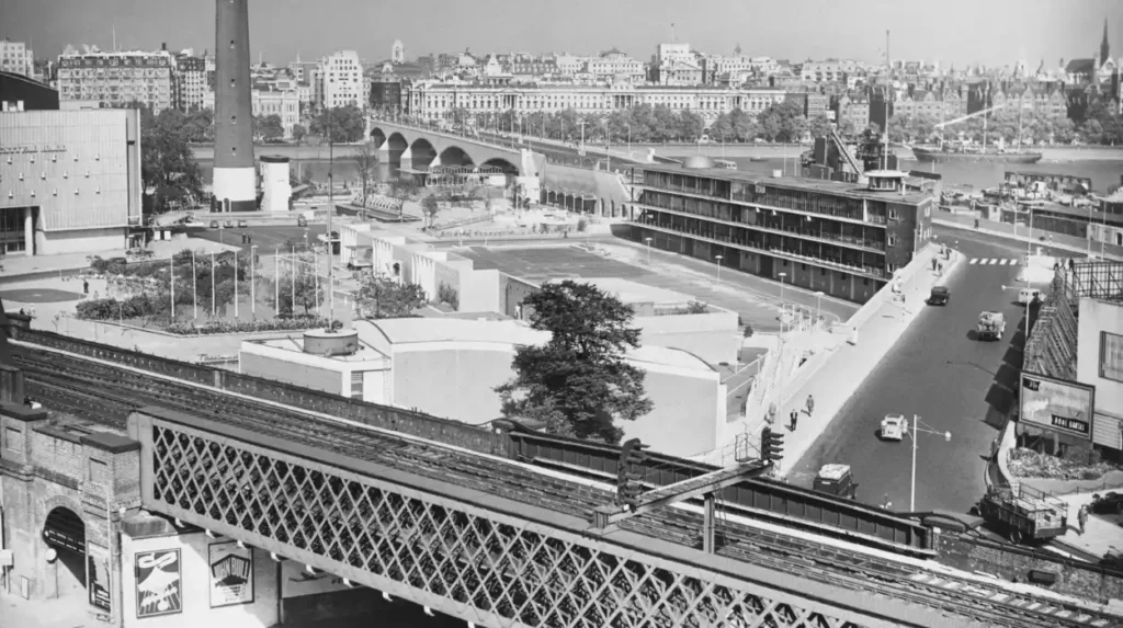
The arrival of the railway created an even greater transformation. The first Waterloo Station opened in 1848. Railway expansion continued through the nineteenth century, while Hungerford Bridge and its railway viaduct connected the South Bank to the Charing Cross area. Waterloo Junction, now associated with Waterloo East, opened in 1869.
Railway infrastructure consumed substantial amounts of land. It also brought workers, passengers and commercial activity into an area already containing factories and housing.
The result was a more intensely urban South Bank. The district was no longer simply a riverside industrial margin. It became an important transport corridor linking the Thames waterfront with central London and wider railway networks.
Which industries shaped South Bank during the nineteenth century?
Nineteenth-century South Bank contained industries such as brewing, pottery, artificial-stone production, timber processing, printing, food production and engineering, with the Thames providing transport for heavy materials and the growing metropolis supplying demand for manufactured goods.
The nineteenth century was the peak period of South Bank’s industrial identity. Manufacturing responded directly to London’s expanding population and construction needs.
Brewing was particularly important. The Lion Brewery stood on the site later occupied by the Royal Festival Hall. It operated from the nineteenth century until its closure in 1941. Its presence illustrates the scale of industrial activity once located beside the modern cultural district.
The South Bank also supported lead works, candle production, printing and building-material industries. Industrial premises were frequently positioned near roads, railway lines and wharves because businesses depended on efficient movement of raw materials.
The Thames was central to this economic system. Coal, timber, grain and other heavy commodities could arrive by water. Finished goods could then move into London through roads and railways.
Manufacturing also created employment. Workers lived close to factories and transport routes, producing a dense urban landscape of homes, workshops and industrial premises.
The industrial character extended eastward into Bankside and Southwark. That neighbouring waterfront contained breweries, glassworks, warehouses, engineering works and gas infrastructure. The Greater London Industrial Archaeology Society identifies the river as a fundamental reason for the concentration of these industries.
This industrial geography explains why modern South Bank contains such a strong contrast between surviving Victorian infrastructure and twentieth-century cultural architecture.
Why was the Thames Embankment important to South Bank’s development?
The Thames Embankment transformed South Bank by reclaiming land, improving flood protection and supporting modern sanitation; the Albert Embankment project of 1866–1869 reclaimed 37 acres and formed part of Joseph Bazalgette’s wider London sewer system.
Victorian engineers transformed London’s relationship with the Thames. Joseph Bazalgette, Chief Engineer of the Metropolitan Board of Works, developed major sewer infrastructure to remove sewage from densely populated districts.
The Albert Embankment was constructed between 1866 and 1869. The project reclaimed 37 acres of land while strengthening the river edge. It formed part of a wider programme of flood protection and sewer construction.
The embankment changed the physical boundary between the city and the river. Previously, the foreshore contained mud, working waterfronts and irregular edges. The engineered embankment created a more controlled riverside environment.
The project also enabled important institutional development. St Thomas’ Hospital was constructed on reclaimed land, opening in 1871. The hospital became one of the most significant institutions on the South Bank.
The embankment therefore had several consequences. It improved sanitation, stabilised the riverbank, reclaimed usable land and supported the expansion of major public institutions.
The Victorian South Bank became increasingly connected to London’s administrative, medical, commercial and transport systems. Its industrial identity remained strong, but the groundwork for a more formal civic district had been established.
How did County Hall change the South Bank?
County Hall introduced a major civic function to South Bank when the London County Council established its headquarters beside Westminster Bridge; its construction replaced industrial land and helped establish the riverside as an important administrative district.
County Hall was built for the London County Council, the principal elected authority responsible for London government from 1889 until the council was abolished in 1965.
Construction began during the early twentieth century, with the first section opening in 1922. The complex expanded during the following decades. Its position beside Westminster Bridge gave the South Bank a prominent civic landmark opposite the Palace of Westminster.
The site had previously supported industrial uses, including the Lion Brewery and other commercial premises. The replacement of industrial land with a major public institution demonstrated the changing role of the waterfront.
The building also reinforced South Bank’s relationship with central government and public administration. Across the river stood Westminster, the centre of national parliamentary government. County Hall provided a corresponding institutional presence on the southern bank.
The famous South Bank Lion associated with the former brewery was retained as a physical reminder of the industrial past. The lion remains near Westminster Bridge, providing a direct connection between the modern civic landscape and the earlier industrial waterfront.
How did the First World War and interwar period affect South Bank?
The First World War, economic change and expanding transport infrastructure altered South Bank without eliminating its industrial identity; printing works, railway infrastructure, factories, offices, housing and public institutions increasingly occupied the district before the Second World War.
South Bank entered the twentieth century as a complex urban district rather than a single-purpose industrial zone. Manufacturing continued alongside housing, transport and public administration.
Printing became significant in the Waterloo area. W. H. Smith & Son established a printing works at Stamford Street in 1914. London County Council later operated a printing school in the area.
Railways remained equally important. Waterloo Station had expanded significantly, while railway bridges and viaducts physically divided parts of the district.
The interwar period also brought architectural and institutional change. County Hall grew in importance, while the waterfront remained occupied by industrial premises.
South Bank’s physical density increased because industrial businesses required land close to transport. Workers required nearby housing. Public authorities required offices and institutions. These demands created a tightly integrated urban environment.
By the late 1930s, the district contained the infrastructure of a major metropolitan economy. Its proximity to central London also made it vulnerable during wartime bombing.
How did the Second World War change South Bank?
The Second World War caused extensive bombing damage across the industrial South Bank, destroying or damaging factories, warehouses and other structures; the resulting cleared land later enabled a radical post-war redevelopment centred on culture, design and public space.
South Bank suffered significant bombing during the Second World War. Industrial buildings and transport infrastructure were especially exposed because the district contained factories, railway facilities and major roads.
The destruction fundamentally altered the development possibilities of the waterfront. Historic industrial buildings disappeared, leaving cleared areas that post-war planners could redesign.
Historic England records that the industrial South Bank sustained heavy bombing and that parts of the district were subsequently cleared for redevelopment, including land used for the 1951 Festival of Britain.
The wartime destruction did not simply remove buildings. It disrupted the economic geography that had supported South Bank for generations.
Post-war Britain faced severe housing shortages, industrial reconstruction, rationing and economic constraints. Yet the government also wanted to demonstrate national recovery and technological progress.
South Bank became a suitable location for that message. Large areas had already been cleared. The district stood beside the Thames and close to Waterloo Station. It was accessible to visitors from London and beyond.
The physical destruction of the industrial landscape therefore became one of the conditions that enabled its cultural transformation.
Why was the Festival of Britain important to South Bank?
The 1951 Festival of Britain transformed South Bank into a national showcase of art, science, architecture, industry and design, with the Royal Festival Hall becoming its permanent architectural legacy and the foundation of today’s Southbank cultural district.
The Festival of Britain opened in 1951, six years after the end of the Second World War. It was inspired partly by the centenary of the Great Exhibition of 1851 but was designed as a celebration of contemporary Britain.
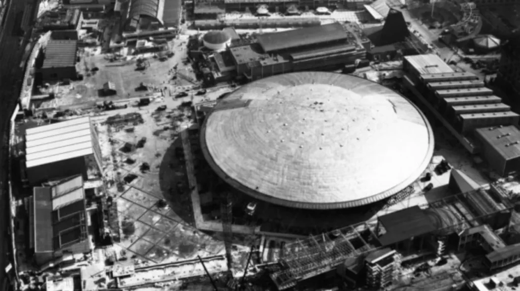
The principal London exhibition occupied the South Bank between Waterloo Bridge and County Hall. The South Bank Exhibition included pavilions, displays and landmark structures such as the Dome of Discovery and Skylon.
The Festival was intended to demonstrate national recovery through architecture, science, technology, art and design. The Southbank Centre describes it as a nationwide celebration whose central London site attracted almost 8.5 million visitors.
The Royal Festival Hall was the exhibition’s principal permanent building. Its foundation stone was laid in 1949, and the building opened on 3 May 1951.
The Festival site itself was temporary. Most of its pavilions were removed after the event. The Royal Festival Hall survived and became the foundation for a permanent cultural complex.
This distinction is essential to understanding South Bank history. The Festival did not simply create a temporary exhibition. It established a new long-term planning concept for the district.
How did the Royal Festival Hall establish South Bank as a cultural quarter?
The Royal Festival Hall established South Bank’s permanent cultural identity after opening in 1951, providing a major concert venue that became the foundation for additional arts buildings and a long-term concentration of music, visual art, literature and public cultural activity.
The Royal Festival Hall was designed by the London County Council Architects’ Department, with Sir Leslie Martin, Robert Matthew, Peter Moro and Edwin Williams among the principal architects associated with the project. Historic England lists it as a Grade I building.
Its modernist architecture represented a major break from the industrial structures that previously occupied much of the site. Its large auditorium, public foyers and riverside setting created a new relationship between architecture and public culture.
The cultural programme expanded during the following decades. In 1967, the Queen Elizabeth Hall, Purcell Room and Hayward Gallery opened as a new complex. Historic England recognises these buildings as nationally significant examples of post-war arts architecture.
The Southbank Centre’s later history includes music, literature, visual art and public festivals. The Royal Festival Hall hosted major international performers and events, while the Hayward Gallery became an important venue for temporary exhibitions.
The introduction of the Greater London Council’s open-foyer policy in 1983 further changed the relationship between the arts complex and the public. The foyers became accessible throughout the day rather than primarily before performances.
The cultural district therefore developed through successive institutions rather than a single redevelopment project.
How did the National Theatre expand South Bank’s cultural identity?
The National Theatre strengthened South Bank’s cultural role when its permanent building opened in 1976, adding a major institution for British theatre and creating a significant post-war architectural group alongside the Royal Festival Hall and other arts venues.
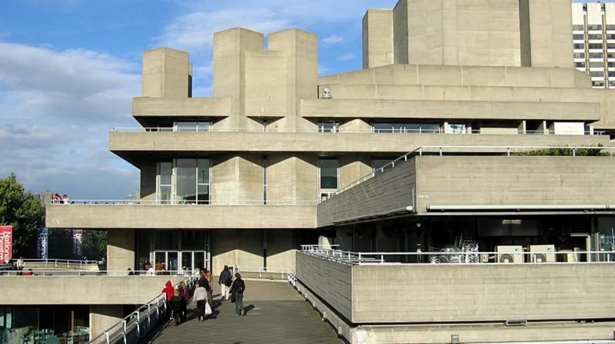
The Royal National Theatre opened its South Bank building in 1976. The building was designed by Denys Lasdun and became one of the defining examples of British Brutalist architecture.
Brutalism is a twentieth-century architectural movement associated with exposed concrete, strong geometric forms and an emphasis on structural mass. The National Theatre uses these characteristics extensively.
The building expanded South Bank’s cultural role beyond music and visual art. Theatre became another major component of the district’s public identity.
Historic England lists the National Theatre as Grade II*. It forms an important post-war arts complex with the Grade I Royal Festival Hall and other listed cultural buildings.
The architecture also demonstrates an important principle of South Bank’s history. The post-war cultural quarter did not reproduce the nineteenth-century urban fabric. It introduced large public buildings, terraces, elevated walkways and open spaces.
This architectural approach remains central to how South Bank is understood today.
What other cultural institutions became important on South Bank?
South Bank’s cultural expansion produced a connected group of major institutions, including the BFI Southbank, Southbank Centre, National Theatre, Hayward Gallery, Royal Festival Hall and National Poetry Library, creating a dense concentration of public cultural activity beside the Thames.
The Southbank Centre now occupies an 11-acre riverside site incorporating the Royal Festival Hall, Queen Elizabeth Hall, Purcell Room, Hayward Gallery and National Poetry Library.
The BFI Southbank added another major cultural function. The British Film Institute is the United Kingdom’s principal organisation for film heritage and operates cinema and archival programmes at its South Bank complex.
County Hall continued to provide a civic landmark, although its functions changed after the abolition of the London County Council and later Greater London Council.
The South Bank also developed public spaces connecting the institutions. Pedestrian routes, riverside terraces and undercroft areas created a more continuous cultural environment.
The Undercroft became particularly significant for skateboarding. The Southbank Centre identifies it as a major location in the development of British skateboarding from the 1970s.
This history demonstrates that cultural transformation was not limited to formal institutions. Informal public uses also became part of South Bank’s heritage.
Which historic structures still reveal South Bank’s industrial past?
Modern South Bank retains industrial evidence through surviving railway structures, historic roads, waterfront alignments, the South Bank Lion, older warehouses and infrastructure, allowing visitors to identify physical remnants of the nineteenth-century manufacturing and transport landscape.
The South Bank Lion is one of the clearest surviving symbols of the former industrial landscape. It is associated with the Lion Brewery, whose former site became part of the Festival of Britain area.
Railway infrastructure provides another important historical layer. Hungerford Bridge and its railway viaduct remain prominent features of the district. The viaduct cuts through the Southbank Centre complex and demonstrates how nineteenth-century transport infrastructure continues to influence the modern cultural landscape.
Older streets also preserve the relationship between industrial premises and the river. Roads such as Belvedere Road and Stamford Street reflect historic patterns of movement around the former industrial and railway districts.
The surviving architecture is not limited to individual listed buildings. The relationship between roads, bridges, embankments and the river is itself historical evidence.
Industrial archaeology helps reconstruct the buildings that no longer exist. Records identify former breweries, wharves, printing works, timber yards, factories and utility sites. These sources allow researchers to connect present-day buildings with earlier economic functions.
For heritage preservation, this layered approach is important. South Bank’s history exists both in preserved monuments and in the physical structure of the district.
How has South Bank been preserved as a historic cultural landscape?
South Bank has been preserved through listed buildings, conservation policies, archival research and continued use of post-war architecture, with the Royal Festival Hall, National Theatre and Queen Elizabeth Hall complex providing protected examples of twentieth-century cultural design.
Historic England protects significant South Bank buildings through statutory listing. The Royal Festival Hall is Grade I, while the National Theatre is Grade II*. The Queen Elizabeth Hall, Purcell Room and Hayward Gallery complex is also recognised for its architectural and cultural significance.
Conservation does not mean freezing the district in one historical period. South Bank contains multiple layers of development. Medieval and early modern river conditions, eighteenth-century industry, nineteenth-century infrastructure, twentieth-century civic buildings and post-war cultural architecture all form part of its historical record.
The Southbank Centre maintains an archive documenting its history. In 2026, the organisation is marking the 75th anniversary of the Royal Festival Hall and the Festival of Britain.
The anniversary also demonstrates how institutional archives preserve personal memories alongside architectural records. Oral histories, photographs, plans, programmes and objects provide evidence about how people experienced the district.
For educators and heritage researchers, South Bank offers an unusually concentrated study area. A short riverside route contains evidence of industrialisation, transport engineering, wartime destruction, post-war planning and cultural redevelopment.
To experience this historic district in person today, consult our comprehensive [Best Historic Attractions in the City of London Every Visitor Should Experience] for itineraries and visiting parameters.
What does South Bank’s history reveal about London’s wider development?
South Bank demonstrates how London repeatedly transformed marginal land through transport investment, industrialisation, civic planning, wartime reconstruction and cultural development, making the district an important case study in the changing relationship between the Thames, urban economy and public life.
The history of South Bank follows several connected stages. The first was a low-lying riverside landscape shaped by flooding and agriculture. The second was industrialisation, when wharves, factories and manufacturing businesses used the river for transport.
The third stage was Victorian infrastructure. Bridges, roads, railways, embankments, sewers and public institutions integrated the area into modern London.
The fourth stage was wartime destruction. Bombing removed significant portions of the industrial landscape and created cleared land for reconstruction.
The fifth stage began with the Festival of Britain in 1951. The Royal Festival Hall established a permanent cultural institution on the former industrial waterfront.
The sixth stage was the expansion of the cultural quarter through buildings such as the Queen Elizabeth Hall, Hayward Gallery and National Theatre.
The modern South Bank therefore represents more than a collection of attractions. Its architecture records successive changes in London’s economy, government, technology and cultural policy.
The district also demonstrates the long-term importance of the Thames. The river first attracted industries because it provided transport. Later, the riverside became an important setting for civic architecture, cultural institutions and public space.
South Bank’s future historical significance rests in this layered character. Its surviving buildings and infrastructure preserve evidence of industrial London while its cultural institutions document the post-war transformation of the capital.
The history remains visible because redevelopment did not erase every earlier layer. Bridges, railway viaducts, embankments, listed buildings, monuments and street patterns continue to connect contemporary South Bank with its industrial and civic past.
For history enthusiasts, cultural tourists, educators and heritage researchers, South Bank provides a compact record of London’s transformation from riverside industry to a major cultural quarter. Its significance lies not in one building or one historical event, but in the documented sequence of changes that reshaped the southern bank of the Thames.
Frequently Asked Question
What is the history of London’s South Bank?
London’s South Bank developed from a low-lying Thames-side landscape into an industrial waterfront during the 17th and 18th centuries. Victorian transport and infrastructure expanded the area before wartime destruction and the 1951 Festival of Britain transformed it into a cultural quarter.