Greenwich occupies a unique position in British and world history because it united royal power, naval development, scientific research, global navigation and international timekeeping within one historic landscape on the River Thames. Its institutions helped Britain build maritime capacity and established standards that influenced navigation and global communication.
- Why did Greenwich become central to Britain’s maritime history?
- How did royal power shape the development of Greenwich?
- Why was the Royal Observatory Greenwich founded in 1675?
- How did Greenwich help solve the longitude problem?
- How did Greenwich become the world’s reference point for longitude?
- What is Greenwich Mean Time and why did it become so important?
- How did Greenwich influence Britain’s growth as a maritime power?
- Why are the buildings of Maritime Greenwich historically important?
- How did Greenwich connect architecture, science and maritime heritage?
- What modern institutions preserve Greenwich’s maritime legacy?
- Why does Greenwich still matter to the modern world?
- How does Greenwich’s history continue to define Britain’s maritime legacy?
- What is the lasting historical significance of Greenwich?
- Frequently Asked Question
The historic district developed over several centuries. Greenwich contained a royal palace, a major naval welfare institution, a purpose-built scientific observatory and, later, one of the world’s leading maritime museums. The Royal Observatory Greenwich became particularly important because astronomical observations conducted there supported the measurement of longitude and the development of Greenwich Mean Time.
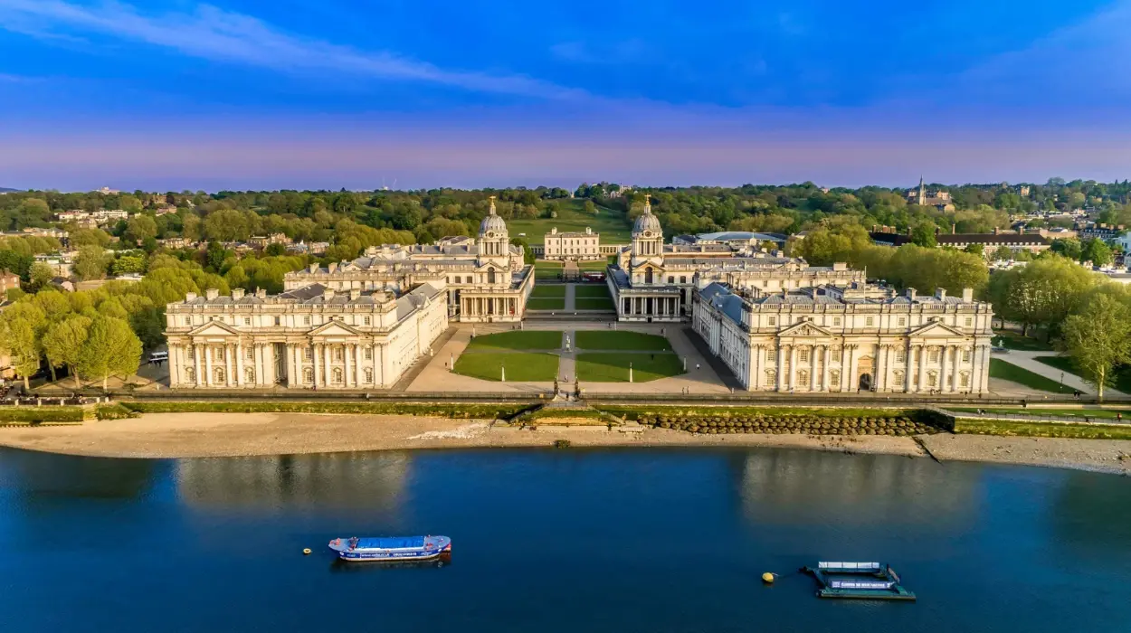
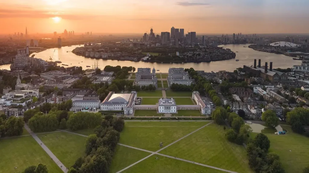
Maritime Greenwich was inscribed on the UNESCO World Heritage List in 1997. The designated property covers 109.47 hectares and includes the Royal Observatory, the Queen’s House, the Old Royal Naval College and Greenwich Park. UNESCO identifies the site as an exceptional combination of architectural, scientific and maritime heritage.
Greenwich therefore represents more than a historic London district. It records the relationship between Britain’s political institutions and its expansion as a maritime power. It also explains how a local astronomical reference point became the basis for an international system of longitude and time.
Why did Greenwich become central to Britain’s maritime history?
Greenwich became central to Britain’s maritime history because royal patronage, the River Thames, naval institutions and scientific research developed there together, creating a national centre for navigation, seafaring welfare, astronomical observation and the measurement systems required for global maritime operations.
Greenwich’s location on the south bank of the River Thames gave it strategic importance long before the establishment of modern scientific institutions. The Thames connected Greenwich directly with the City of London and the wider North Sea. Ships, naval personnel, merchants and royal households could move along this waterway between London and Britain’s maritime routes.
The area also developed a strong relationship with the English monarchy. Greenwich Palace became one of the Tudor dynasty’s important royal residences. Henry VIII was born there in 1491, Mary I in 1516 and Elizabeth I in 1533. These royal associations gave Greenwich political importance during a period when England was developing stronger naval institutions and expanding overseas activity.
Britain’s maritime development required more than ships and ports. Long-distance navigation required accurate knowledge of position, astronomical observation and reliable information about time. By the seventeenth century, these requirements had become matters of national importance.
The establishment of the Royal Observatory at Greenwich in 1675 directly connected scientific research with maritime strategy. Charles II authorised the institution to improve astronomical knowledge and support navigation, particularly the determination of longitude at sea. This made Greenwich a national scientific centre with a practical maritime purpose.
The district also became associated with naval welfare. From the late seventeenth century, the former palace site was transformed into the Royal Hospital for Seamen. This institution provided accommodation and support for injured and retired naval personnel.
These interconnected institutions created a concentrated maritime landscape. The Royal Observatory addressed navigation and astronomy. The Royal Hospital supported seafarers. The Thames connected the district with naval and commercial activity. The royal buildings demonstrated state authority and patronage.
This concentration explains why Greenwich became permanently associated with Britain’s maritime identity.
How did royal power shape the development of Greenwich?
Royal power shaped Greenwich by establishing the area as a major residence, financing architectural development and supporting scientific institutions, allowing the Crown to connect political authority with naval welfare, astronomical research, landscape design and Britain’s expanding international maritime ambitions.
Greenwich developed as a royal centre over centuries. Its position outside the crowded medieval City of London provided monarchs with access to the Thames and extensive surrounding land.
The Tudor Palace of Greenwich became one of England’s important royal residences. Its historical importance extended beyond architecture because the palace was closely connected with the Tudor monarchy and the political transformation of England during the sixteenth century.
Much of the Tudor palace later disappeared. The Queen’s House remains the most important surviving element of the broader royal landscape. Designed by architect Inigo Jones and constructed between approximately 1616 and 1638, it introduced a fully classical architectural language to England.
UNESCO identifies the Queen’s House as Britain’s first Palladian building and recognises its influence on later British architecture. The building therefore represents Greenwich’s importance in the development of both royal and architectural history.
Royal patronage continued under Charles II. Greenwich Park was reshaped during the seventeenth century, while the Royal Observatory was founded in 1675.
The decision to establish a scientific observatory reflected a wider transformation in government. European states increasingly used mathematics, astronomy and technical knowledge to strengthen military and commercial capacity. Accurate navigation had direct consequences for naval operations, international trade and overseas expansion.
Greenwich became an example of state-sponsored science. The Crown did not establish the Observatory solely for abstract astronomical research. Its founding purpose included improving navigation and solving the practical problem of determining longitude.
The later Royal Hospital for Seamen added another dimension. The Crown and national institutions recognised naval service as central to Britain’s security and economy. Greenwich consequently developed into a physical representation of the relationship between monarchy, naval power and public institutions.
UNESCO describes the surviving ensemble as evidence of royal patronage across the seventeenth and eighteenth centuries. The Queen’s House, Royal Hospital complex, Royal Observatory and designed park form a historically connected landscape rather than isolated monuments.
Why was the Royal Observatory Greenwich founded in 1675?
The Royal Observatory Greenwich was founded in 1675 to improve astronomical knowledge for navigation, with particular attention to determining longitude at sea, a problem that affected naval safety, commercial shipping, international trade and Britain’s capacity to operate across distant oceans.
The seventeenth century created major challenges for maritime navigation. Sailors could determine latitude with increasing accuracy by observing the Sun and stars. Longitude, which measures east-west position, remained far more difficult to calculate during a voyage.
An error in longitude could place a ship hundreds of miles from its estimated position. This created serious risks near coastlines and complicated the movement of naval and merchant vessels across the Atlantic, Indian and Pacific Oceans.
The Royal Observatory was created to address this national problem.
John Flamsteed became the first Astronomer Royal. His work involved systematic observation of celestial bodies and the production of increasingly accurate astronomical data. Reliable observations were essential because navigators required dependable reference information when calculating their positions.
The Observatory became Britain’s earliest purpose-designed scientific building. Its location in Greenwich Park also provided a stable observational site away from the dense urban development of central London during the seventeenth century.
Astronomical observation depended on precision. Observers recorded the positions and movements of stars, the Moon and other celestial objects. These records supported astronomical tables that could later be used by navigators.
The Observatory’s importance therefore extended beyond the building itself. It became part of a wider information system involving observations, mathematical calculations, printed publications and practical navigation.
This process gradually linked Greenwich with international maritime activity. British ships carried navigational methods developed through scientific research, while the data produced in Greenwich circulated through publications and professional networks.
The Observatory’s long-term significance came from continuity. Generations of Astronomers Royal and scientific staff developed observations and standards over centuries. That institutional continuity helped establish Greenwich as a trusted reference point.
How did Greenwich help solve the longitude problem?
Greenwich helped solve the longitude problem by producing precise astronomical observations, supporting navigational calculations and publishing standardised data, while advances in marine chronometers and lunar-distance methods enabled sailors to determine their east-west position with substantially greater accuracy.
The longitude problem was one of the defining technical challenges of eighteenth-century navigation.
Latitude could be estimated by measuring the altitude of celestial objects above the horizon. Longitude required a comparison between local time and the time at a known reference location.
The Earth rotates approximately 360 degrees in 24 hours. This relationship means that time differences correspond to differences in longitude. A one-hour difference represents approximately 15 degrees of longitude.
A navigator therefore needed two forms of information. The first was local time at the ship’s position. The second was the time at an agreed reference location.
Astronomy offered one solution. The lunar-distance method used the observed angular distance between the Moon and selected celestial bodies. Tables predicted these astronomical positions for specific times at a reference meridian.
Nevil Maskelyne, Astronomer Royal from 1765 to 1811, played a major role in making this information accessible to navigators. In 1766, the first edition of the Nautical Almanac was published. The publication reduced the complex calculations required for lunar-distance navigation and became widely used internationally.
The development of accurate marine timekeepers provided another solution. John Harrison’s work on precision chronometers demonstrated that a reliable clock could preserve the time of a reference location during a sea voyage.
A navigator who knew Greenwich time and calculated local solar time could determine longitude through the difference between them.
These developments transformed navigation through a combination of scientific institutions and technical innovation. Greenwich supplied authoritative astronomical data and a recognised reference system. Precision instruments made the practical use of time increasingly reliable.
By around 1770, Greenwich had played a major role in improving methods for determining longitude and strengthening navigational practice.
The solution was not a single invention or individual achievement. It resulted from connected developments involving observatories, astronomers, instrument makers, navigators, mathematical tables and marine chronometers.
Greenwich became the institutional centre of this British system.

How did Greenwich become the world’s reference point for longitude?
Greenwich became the world’s principal longitude reference because British nautical charts, astronomical publications and maritime navigation increasingly used its meridian, leading international delegates in 1884 to adopt the Greenwich Meridian as the global Prime Meridian for international standardisation.
A meridian is an imaginary line running from the North Pole to the South Pole. Longitude measures locations east or west from an agreed zero-degree meridian.
Before international standardisation, countries used different prime meridians. Maps and navigation systems therefore lacked a universal geographical starting point.
Britain increasingly used Greenwich as its national reference point. The modern Greenwich Meridian was fixed at the Royal Observatory in 1851.
The growth of British maritime activity gave this reference practical international influence. British charts and navigational publications circulated widely. Sailors increasingly measured longitude from Greenwich.
This practical usage became important when the International Meridian Conference met in Washington, D.C., in 1884.
Delegates considered the need for a single Prime Meridian for international navigation and timekeeping. Greenwich had already gained widespread acceptance through maritime practice.
The conference adopted the Greenwich Meridian as the international Prime Meridian. Longitude 0 degrees at Greenwich became the reference point from which global longitude could be measured east and west.
The decision created an international standard with practical consequences.
Maps could use a common geographical reference. Navigators could work from consistent longitude systems. International timekeeping could be organised around a shared starting point.
The significance of the 1884 decision extended far beyond Britain. Greenwich became part of a global technical infrastructure.
The historical Prime Meridian at the Royal Observatory remains one of London’s most recognisable scientific landmarks. Its importance lies in the international standardisation process that developed around it rather than simply the visible line marked at the site.
Modern satellite navigation systems use more complex geodetic reference systems, including internationally defined Earth-centred coordinates. The historical Greenwich Meridian nevertheless remains fundamental to the history of global longitude and timekeeping.
What is Greenwich Mean Time and why did it become so important?
Greenwich Mean Time became important because it provided a standard time based on astronomical observation at Greenwich, allowing Britain and later international systems to coordinate navigation, railways, communications and civil time through a shared chronological reference.
Greenwich Mean Time, commonly known as GMT, developed from astronomical observation at the Royal Observatory.
Mean solar time differs from apparent solar time. The apparent movement of the Sun does not produce perfectly equal intervals throughout the year because of the Earth’s orbit and axial position. Mean time uses an averaged solar measure to create a consistent system.
Astronomers at Greenwich established a standard reference based on observations and calculations. This system became increasingly important as Britain developed faster communication and transportation networks.
Local time had previously varied between towns. Noon occurred at different moments because the Sun reached its highest position at different times across the country.
This system became increasingly impractical during the nineteenth century.
Railways required standardised timetables. Telegraph networks transmitted information across long distances. Commercial organisations required synchronised schedules.
Greenwich time became the practical solution.
Railway companies increasingly adopted Greenwich Mean Time during the nineteenth century. Public clocks and national institutions followed this process of standardisation.
In 1880, GMT became the legal time of Great Britain.
This legal adoption demonstrated how a scientific standard developed for astronomy and navigation had entered everyday life.
The expansion of international communications increased GMT’s wider significance. Telegraphy enabled rapid transmission of time signals. Later technologies, including radio broadcasting, allowed precise time information to reach much larger audiences.
In 1924, the BBC broadcast a Greenwich time signal for the first time.
Greenwich Mean Time subsequently became part of the international history of coordinated timekeeping. Modern Coordinated Universal Time, or UTC, uses atomic clocks rather than direct astronomical observations as its primary basis. UTC nevertheless retains Greenwich’s historical position as the world’s principal longitudinal and timekeeping reference.
The transition from GMT to UTC demonstrates continuity and technological change. Greenwich supplied the geographical framework. Atomic time supplied greater scientific precision.
How did Greenwich influence Britain’s growth as a maritime power?
Greenwich influenced Britain’s maritime growth by supporting accurate navigation, providing institutions for naval welfare and education, and connecting scientific knowledge with practical seafaring, strengthening the infrastructure required for British naval operations, commerce and international maritime administration.
Britain’s maritime expansion depended on institutional systems as well as individual voyages.
Ships required trained personnel. Navigators required accurate information. Governments required reliable charts and scientific observations. Naval communities required welfare and educational institutions.
Greenwich contributed to each of these areas.
The Royal Observatory supported navigation through astronomy and timekeeping. Its observations helped create authoritative reference data for maritime calculations.
The Royal Hospital for Seamen supported naval personnel who had been injured or retired after service. The institution demonstrated the importance of naval welfare within Britain’s national maritime system.
The site later developed an educational role. A school for the children of seamen was established at Greenwich, while the Queen’s House later became associated with naval orphan education. These institutions reflected the long-term social infrastructure surrounding British maritime service.
The nineteenth century brought further changes.
The Greenwich Hospital ceased operating as a residential home for seamen during the 1860s. In 1873, the Royal Naval College moved into the historic buildings.
The transformation ensured that the site retained a direct connection with naval education and professional development.
Greenwich therefore experienced several institutional eras, including royal residence, naval welfare centre, naval education centre and national heritage centre. Examples include Greenwich Palace, Greenwich Hospital, the Royal Naval College and the National Maritime Museum.
This continuity is historically significant because each institution adapted the same landscape to Britain’s changing maritime requirements.
The buildings also demonstrate the relationship between architecture and national institutions. Christopher Wren’s master plan for the Royal Hospital created one of Britain’s most significant Baroque architectural ensembles.
UNESCO identifies the architectural complex as evidence of British artistic and scientific development during the seventeenth and eighteenth centuries.
Why are the buildings of Maritime Greenwich historically important?
The buildings of Maritime Greenwich are historically important because they preserve a connected record of royal government, Palladian architecture, Baroque planning, naval welfare, scientific research and maritime education within one internationally recognised cultural landscape beside the River Thames.
The importance of Maritime Greenwich comes from the relationship between its structures.
The Queen’s House represents the transformation of British architecture during the seventeenth century. Inigo Jones introduced classical and Palladian principles that influenced later buildings throughout Britain.
The Royal Observatory represents the institutionalisation of scientific research. It was constructed specifically for astronomical work and became associated with navigation, longitude and timekeeping.
The Old Royal Naval College represents the naval and welfare history of the site. Its monumental architecture reflects the national importance attached to Britain’s maritime institutions.
Greenwich Park provides the landscape setting connecting these buildings. The park was reshaped during the seventeenth century and became an essential component of the planned historic environment.
UNESCO describes Maritime Greenwich as an exceptional ensemble demonstrating English artistic and scientific achievement. The site was inscribed on the World Heritage List in 1997 under four cultural criteria: (i), (ii), (iv) and (vi).
The property contains several protected heritage assets. UNESCO records that the hospital, Queen’s House and observatory buildings are Grade I listed structures, while Greenwich Park is a Grade I registered park and garden.
The wider town centre also forms part of the historic setting through its conservation status.
The preservation of this landscape allows visitors and researchers to examine physical evidence from different historical periods.
To experience this historic landmark in person today, consult our comprehensive [Best Cultural Experiences in Camden for Markets, Music, and Independent Street Food] for itineraries and visiting parameters.
How did Greenwich connect architecture, science and maritime heritage?
Greenwich connected architecture, science and maritime heritage by concentrating royal residences, designed landscapes, naval institutions and astronomical research within one district, demonstrating how political authority funded buildings and knowledge systems that supported Britain’s national and international maritime activities.
The history of Greenwich cannot be understood through one discipline alone.
Architecture explains the development of the Queen’s House and the Old Royal Naval College. Political history explains royal patronage and the strategic importance of naval institutions. Scientific history explains the Observatory’s role in astronomy and timekeeping.
Maritime history connects these subjects.
The buildings provided institutional spaces. The Observatory housed scientific observation. The Hospital housed and supported seafarers. Educational institutions trained and supported naval communities.
The architectural quality of the district also reflected national priorities.
The Crown invested in monumental buildings because Greenwich represented more than local government. It became a visible expression of state authority and Britain’s relationship with the sea.
The scientific work at the Observatory followed the same pattern. Astronomical research received institutional support because it had practical consequences for navigation.
UNESCO explicitly connects Greenwich’s scientific work with the development of navigation, the Greenwich Meridian and Greenwich Mean Time.
This combination gives Maritime Greenwich unusual historical density.
A visitor can examine a royal architectural landmark, a naval complex and a scientific observatory within the same historic area. The physical proximity of these institutions makes the relationship between Britain’s political, scientific and maritime development visible.
What modern institutions preserve Greenwich’s maritime legacy?
Modern institutions preserve Greenwich’s maritime legacy through museum collections, heritage management, conservation programmes and public education, ensuring that the Royal Observatory, Queen’s House, Old Royal Naval College and surrounding landscape remain accessible evidence of Britain’s scientific and naval history.
The preservation of Greenwich requires cooperation between multiple organisations.
The Royal Observatory and Queen’s House are associated with the National Maritime Museum’s heritage collections and custodianship arrangements. The wider maritime heritage of the district is interpreted through museums, archives and educational programmes.
The Old Royal Naval College is maintained as a major heritage site while continuing to function within a wider educational environment.
Greenwich Park remains an essential part of the historic landscape. Its management includes the conservation of designed features, archaeological resources and significant views.
UNESCO states that Maritime Greenwich is protected through statutory designations, conservation arrangements and planning policies. The property has a defined World Heritage boundary of 109.47 hectares and a buffer zone of 174.85 hectares.
Preservation is important because the site faces pressures associated with urban development.
Tall buildings and changes to the surrounding urban environment can affect the visual integrity of historic landscapes. Conservation planning therefore considers both individual buildings and their wider setting.
The preservation of Greenwich also has educational importance.
Students can study the development of British architecture through the Queen’s House and the Naval College. Historians can examine royal and naval institutions. Researchers can investigate astronomy, navigation and international standardisation.
Genealogical researchers also encounter Greenwich through naval service records, maritime communities and institutions connected with seafarers and their families.
This continuing research value ensures that Greenwich remains an active historical resource rather than a static monument.
Why does Greenwich still matter to the modern world?
Greenwich still matters because its historical systems of longitude and standardised time shaped modern global coordination, while its preserved buildings demonstrate how scientific institutions, maritime infrastructure and international standards developed through long-term cooperation between governments, researchers and navigators.
Modern life depends on coordinated systems.
International travel requires shared schedules. Digital networks depend on precise time standards. Satellite navigation requires globally recognised geographical reference systems.
The technologies have changed, but the historical problem remains familiar: societies require common systems for describing location and coordinating time.
Greenwich played a decisive role in the historical development of those systems.
The adoption of the Greenwich Meridian in 1884 established a widely accepted geographical reference for international longitude. Greenwich Mean Time provided a standard temporal reference that influenced national and international timekeeping.
Modern UTC uses atomic clocks and international scientific coordination. It replaced direct astronomical dependence as the primary method for maintaining civil time. Greenwich nevertheless remains embedded in the language and historical structure of global timekeeping.
The district also matters as a preserved record of how knowledge becomes infrastructure.
Astronomical observations began as scientific measurements. Those measurements became navigational information. Navigational information supported ships and international movement. Standardised time later supported railways, communications and global administration.
Greenwich demonstrates this historical process with unusual clarity.
Its legacy also extends beyond Britain.
The International Meridian Conference transformed a British national reference into an international standard. The global significance of Greenwich therefore developed through adoption and international agreement rather than geographical location alone.
UNESCO recognises this international importance by identifying the site as a place where navigation and astronomy contributed to the establishment of the Greenwich Meridian and Greenwich Mean Time as world standards.
How does Greenwich’s history continue to define Britain’s maritime legacy?
Greenwich continues to define Britain’s maritime legacy because its surviving institutions document the connection between royal authority, naval communities, scientific research and global navigation, preserving the systems and ideas that helped Britain organise maritime activity across several centuries of historical change.
Britain’s maritime legacy includes ships, ports, naval battles and overseas trade. Greenwich adds the institutional and scientific foundations behind those visible achievements.
The district explains how maritime power depended on organised knowledge.
Astronomy improved navigation. Standardised time improved coordination. Accurate longitude reduced uncertainty at sea. Naval institutions supported the people who operated Britain’s ships.
Greenwich also demonstrates how national priorities changed.
The Tudor Palace represented royal residence and political authority. The Royal Observatory represented scientific investment. Greenwich Hospital represented naval welfare. The Royal Naval College represented professional education. The National Maritime Museum represented public preservation and interpretation.
These successive functions created a historical sequence spanning several centuries.
The surviving landscape makes this sequence physically accessible.
The Queen’s House records early classical architecture. The Royal Observatory records scientific development. The Old Royal Naval College records Britain’s naval institutions. Greenwich Park preserves the designed landscape connecting them.
Together, these places explain why Greenwich became internationally significant.
Its greatest historical achievement was the creation and development of systems that travelled far beyond London.
Ships carried Greenwich-based navigational standards across the world’s oceans. Maps adopted Greenwich longitude. Governments and railways adopted standard time. International institutions built later systems upon the need for globally coordinated references.
Greenwich therefore shaped Britain’s maritime legacy through both physical institutions and transferable knowledge.
The historic district remains one of the clearest examples of how a local place can influence global standards.
What is the lasting historical significance of Greenwich?
Greenwich’s lasting historical significance lies in its transformation from royal residence into a centre of maritime science, navigation and international timekeeping, producing institutions and standards that connected British history directly with the global organisation of longitude, time and seafaring knowledge.
Greenwich’s historical development followed a clear long-term progression.
Royal patronage established the district as an important political landscape. Architectural innovation produced nationally significant buildings. Scientific investment created the Royal Observatory in 1675. Astronomical research supported navigation and longitude.
The growth of British maritime activity expanded the international use of Greenwich-based reference systems.
The modern Greenwich Meridian was established at the Observatory in 1851. GMT became legal time in Great Britain in 1880. The International Meridian Conference adopted Greenwich as the world’s Prime Meridian in 1884.
These milestones transformed Greenwich from a British scientific location into a global historical reference.
The significance of the district is therefore both national and international.
For Britain, Greenwich records the development of royal authority, naval welfare, maritime education and scientific research.
For the wider world, it records the development of internationally coordinated longitude and timekeeping.
Maritime Greenwich’s World Heritage status recognises this combined importance. Its architecture, landscape, scientific institutions and maritime associations preserve evidence of the seventeenth- and eighteenth-century developments that changed Britain’s relationship with navigation and global measurement.
The history of Greenwich remains relevant because the modern world continues to depend on precise location and coordinated time.
The instruments have changed. The scientific methods have become more precise. The international systems have expanded.
The central historical achievement remains clear.
Greenwich helped transform astronomy into practical navigation, navigation into international standards, and a local London meridian into one of the defining reference points in the history of the modern world.
For that reason, Greenwich remains permanently connected to Britain’s maritime legacy and the global history of timekeeping.
Frequently Asked Question
What is Greenwich famous for in British maritime history?
Greenwich is famous for its Royal Observatory, naval institutions, royal history and role in developing navigation, longitude measurement and global timekeeping standards.