London’s skyline reflects almost two thousand years of urban development. Roman walls, medieval church towers, Victorian railway infrastructure, twentieth-century civic architecture, and contemporary skyscrapers coexist within one metropolitan landscape. Free rooftop viewing locations provide accessible opportunities to understand this architectural evolution while capturing panoramic photographs without purchasing observation deck tickets. These elevated public spaces also demonstrate how modern London integrates commercial, cultural, and civic developments into a city that preserves its historic character while accommodating continuous growth.
- Why do London’s free rooftop viewpoints provide the best understanding of the city’s skyline?
- Which free rooftop viewpoints offer the most complete panoramas of London?
- How did London’s skyline develop into its distinctive modern form?
- Why does London protect important skyline views through planning laws?
- Which historical landmarks are visible from London’s best free rooftops?
- When is the best time to photograph London’s skyline from free rooftops?
- How do London’s rooftop gardens contribute to urban conservation and sustainability?
- What practical advice helps visitors enjoy London’s free rooftop viewpoints?
- Why do free rooftop viewpoints strengthen London’s cultural identity?
- Frequently Asked Question
Why do London’s free rooftop viewpoints provide the best understanding of the city’s skyline?
London’s free rooftop viewpoints reveal nearly two thousand years of architectural history within a single panorama. Public terraces combine historical landmarks, modern skyscrapers, royal parks, and river corridors, allowing visitors to photograph the capital’s evolving urban landscape without admission charges or restricted viewing periods.
The London skyline differs from many global capitals because height restrictions historically protected important monuments such as St Paul’s Cathedral. This planning philosophy preserved significant sightlines while allowing carefully managed high-rise development in designated commercial districts.
London’s skyline extends across approximately 1,572 square kilometres within Greater London. The River Thames serves as the city’s principal visual corridor, connecting historic settlements, commercial centres, government institutions, and cultural districts.
Public rooftop terraces became increasingly common during the early twenty-first century as commercial developments incorporated accessible civic spaces into office buildings, shopping centres, and mixed-use regeneration projects. These viewing platforms support urban tourism while encouraging public engagement with London’s architectural heritage.
From elevated positions, visitors observe multiple historical periods simultaneously. Roman foundations influenced medieval street layouts. Georgian terraces expanded westward during the eighteenth century. Victorian engineering transformed transportation networks. Modern skyscrapers define London’s international financial districts.
Understanding these relationships enhances skyline photography because every composition documents centuries of continuous urban development rather than isolated landmarks.
Which free rooftop viewpoints offer the most complete panoramas of London?
Several publicly accessible rooftops provide exceptional panoramic views across central London. Each location presents distinct perspectives, architectural compositions, and photographic opportunities while remaining completely free throughout normal operating hours, making them valuable destinations for residents, tourists, educators, and researchers.
The Garden at 120
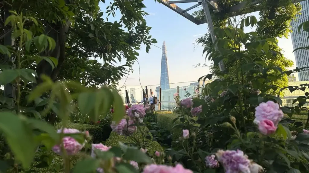
The Garden at 120 occupies the fifteenth floor of 120 Fenchurch Street within the City of London. Opened in 2019, this landscaped public roof garden sits approximately 69 metres above street level.
The terrace overlooks the Tower of London, Tower Bridge, the Shard, the Gherkin, St Paul’s Cathedral, and Canary Wharf. Carefully designed planting schemes complement rather than obstruct panoramic views.
Wide walkways accommodate photographers using tripods during quieter periods, although management policies regulate professional equipment during busy times.
The eastern perspective becomes particularly valuable during sunrise photography, while evening light highlights London’s financial district against the River Thames.
One New Change Rooftop Terrace
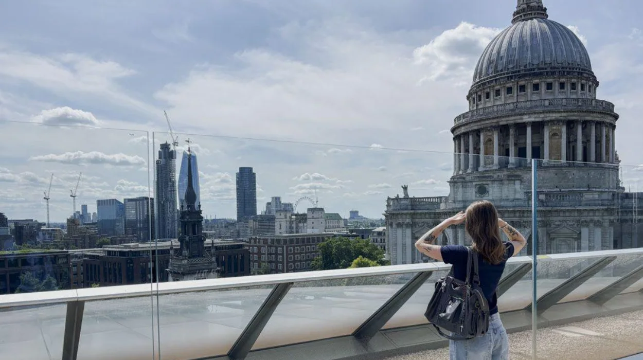
One New Change represents one of London’s most historically significant free rooftop viewpoints because it directly faces St Paul’s Cathedral.
Completed in 2010, the mixed-use development occupies land near one of London’s oldest commercial districts. The rooftop terrace frames Sir Christopher Wren’s cathedral with remarkable clarity.
Photographers capture detailed architectural images without significant foreground obstruction. The location also reveals how contemporary commercial architecture surrounds one of Britain’s most important religious monuments.
Crossrail Place Roof Garden
Located above Canary Wharf’s Elizabeth line station, Crossrail Place Roof Garden combines botanical collections with elevated city views.
The enclosed garden contains plant species reflecting historical trading routes connecting Europe, Asia, and the Americas. These collections acknowledge Canary Wharf’s continuing international commercial significance.
Although partially enclosed, several viewing areas provide excellent perspectives towards central London’s skyline and the financial towers defining eastern London.
The Post Building Rooftop
The Post Building occupies the former Royal Mail sorting office near Oxford Street. Redevelopment transformed industrial infrastructure into commercial offices while incorporating accessible rooftop public spaces.
The rooftop offers extensive western and central London panoramas, including the BT Tower, Centre Point, and surrounding West End districts.
These perspectives highlight post-war reconstruction alongside surviving Victorian and Edwardian architecture.
Roof East Community Spaces
Although Roof East functions primarily as a seasonal leisure venue in Stratford, public access areas offer valuable skyline perspectives towards Queen Elizabeth Olympic Park and central London.
The surrounding regeneration illustrates London’s post-2012 Olympic transformation while preserving industrial heritage through adaptive reuse projects.
How did London’s skyline develop into its distinctive modern form?
London’s skyline developed through successive periods of rebuilding, expansion, disaster recovery, industrialisation, and modern planning. Roman foundations, medieval reconstruction, the Great Fire of 1666, Victorian engineering, and contemporary commercial growth collectively shaped today’s internationally recognised urban panorama.
Roman Londinium, established around AD 47, introduced organised street planning and defensive walls that influenced later development patterns. Portions of these walls remain visible today beneath and around the modern financial district.
Following the Norman Conquest of 1066, monumental stone construction transformed London’s skyline. The Tower of London became a dominant defensive structure, while monasteries and parish churches expanded throughout medieval neighbourhoods.
The Great Fire of London in September 1666 destroyed approximately 13,200 houses, 87 parish churches, and numerous civic buildings across the medieval city. Reconstruction fundamentally reshaped London’s architectural identity.
Sir Christopher Wren designed St Paul’s Cathedral between 1675 and 1710. Its dome dominated London’s skyline for over 250 years, becoming both a religious landmark and national symbol.
The Industrial Revolution introduced railway stations, warehouses, bridges, docks, and factories that expanded London’s physical scale. Victorian engineers constructed iconic structures including Tower Bridge, completed in 1894.
Twentieth-century redevelopment followed wartime bombing, suburban expansion, and economic transformation. Financial deregulation during the 1980s accelerated commercial office construction within the City and Canary Wharf.
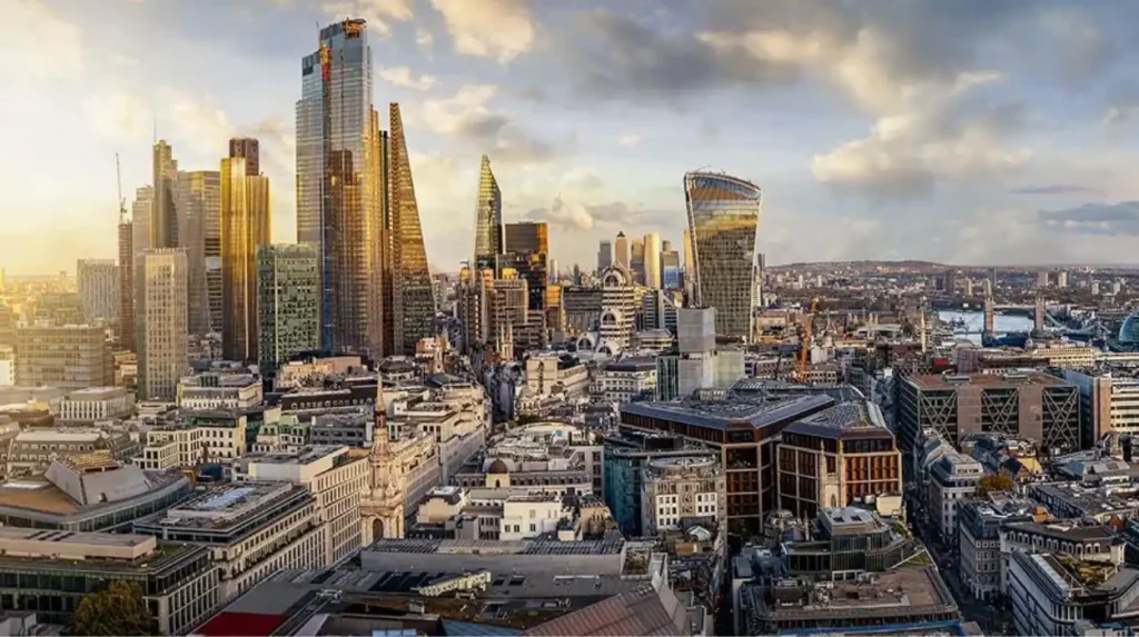
Contemporary skyscrapers such as the Shard, the Gherkin, 22 Bishopsgate, and the Leadenhall Building represent London’s continuing evolution as an international financial centre.
Why does London protect important skyline views through planning laws?
London protects historic skyline views through legally enforced planning policies that preserve visual relationships between nationally significant monuments and surrounding urban development. These regulations balance economic growth with heritage conservation while maintaining internationally recognised city panoramas across designated viewing corridors.
Protected views originated from concerns that uncontrolled commercial development would visually overwhelm historic landmarks.
The London View Management Framework establishes protected sightlines towards St Paul’s Cathedral, the Palace of Westminster, and other nationally important buildings.
Developers proposing tall buildings must demonstrate that projects preserve designated strategic views from identified public locations.
These planning principles explain why London’s skyscrapers concentrate within specific commercial districts rather than surrounding every historic monument.
The City of London Corporation and the Greater London Authority jointly assess major developments affecting protected visual corridors.
This regulatory framework distinguishes London’s skyline from cities where unrestricted vertical growth dominates historic centres.
Photographers benefit because carefully managed development preserves recognisable landmark compositions across multiple generations.
Which historical landmarks are visible from London’s best free rooftops?
London’s free rooftop terraces overlook nationally important landmarks representing Roman, medieval, Tudor, Stuart, Georgian, Victorian, and contemporary periods. These visible monuments collectively illustrate Britain’s political, religious, commercial, military, and architectural history across nearly twenty centuries of continuous urban development.
St Paul’s Cathedral remains London’s most recognisable ecclesiastical landmark. Completed in 1710, its Baroque architecture symbolised national recovery after the Great Fire.
The Tower of London, founded by William the Conqueror during the eleventh century, demonstrates Norman military architecture and royal authority.
Tower Bridge, completed in 1894, represents Victorian engineering innovation combining bascule technology with Gothic Revival architectural styling.
The Palace of Westminster reflects nineteenth-century Gothic Revival architecture following reconstruction after the devastating fire of 1834.
The Shard, completed in 2012, stands approximately 310 metres tall, making it one of Western Europe’s tallest buildings.
The Gherkin, officially 30 St Mary Axe, introduced energy-efficient skyscraper design following completion in 2003.
Canary Wharf illustrates London’s transformation from declining docklands into a globally significant financial district beginning during the late twentieth century.
Every panoramic composition therefore records architectural continuity rather than isolated structures.
To experience these historic landmarks in person today, consult our comprehensive [How London Became Britain’s Cultural Capital Through Innovation, Diversity, and Historical Influence] for itineraries and visiting parameters.
When is the best time to photograph London’s skyline from free rooftops?
Seasonal light, weather conditions, and solar positioning determine skyline photography quality. Early morning, late afternoon, and the golden hour consistently produce balanced illumination, stronger architectural definition, and improved atmospheric visibility across London’s historic and modern districts throughout the year.
Morning photography benefits from reduced atmospheric pollution, lower visitor numbers, and softer eastern light illuminating western-facing landmarks.
Golden hour before sunset creates warm reflections across glass skyscrapers while highlighting historic stone buildings with greater texture.
Blue hour immediately after sunset produces balanced illumination between illuminated buildings and the gradually darkening sky.
Winter often delivers exceptionally clear visibility following cold weather systems because lower humidity reduces atmospheric haze.
Spring and autumn provide moderate temperatures suitable for extended photography sessions without excessive summer crowds.
Professional architectural photographers frequently monitor weather forecasts, cloud cover, and seasonal sunrise positions before selecting rooftop locations.
Stable weather conditions improve long-distance visibility towards Canary Wharf, Wembley Stadium, Alexandra Palace, and Richmond Park.
How do London’s rooftop gardens contribute to urban conservation and sustainability?
Public rooftop gardens improve biodiversity, reduce urban heat, manage rainwater, and expand accessible green infrastructure while preserving valuable public viewing spaces. These developments demonstrate how environmental sustainability complements commercial architecture and heritage-sensitive urban regeneration throughout modern London.
Green roofs reduce surface temperatures compared with conventional roofing materials.
Vegetation absorbs rainfall, reducing pressure on urban drainage systems during heavy storms.
Native flowering plants support pollinating insects including bees, butterflies, and hoverflies within densely developed commercial districts.
Urban biodiversity strategies increasingly encourage rooftop habitat creation alongside sustainable office developments.
The Garden at 120 contains hundreds of drought-tolerant plant species selected for resilience within rooftop environments.
Crossrail Place Roof Garden conserves botanical diversity while educating visitors about historical trade routes connecting Britain with global ecosystems.
These projects demonstrate that modern commercial developments contribute positively to London’s environmental resilience without restricting public access.
What practical advice helps visitors enjoy London’s free rooftop viewpoints?
Planning visits around opening hours, weather forecasts, photography conditions, and transport connections improves the rooftop experience. Respecting site regulations, carrying suitable equipment, and understanding seasonal lighting ensures successful visits while supporting safe and sustainable public access for every visitor.
Most public rooftop terraces operate during standard daytime business hours, although seasonal variations occur.
Checking official management websites before travelling confirms temporary closures resulting from maintenance or private events.
Wide-angle lenses capture extensive panoramas, while telephoto lenses isolate architectural details including church spires, bridges, and modern skyscrapers.
Comfortable footwear supports extended walking because several rooftop locations integrate easily into wider architectural exploration routes.
Public transport provides efficient access through London’s Underground, Elizabeth line, Docklands Light Railway, and extensive bus network.
Respecting designated pathways protects rooftop landscaping while preserving safe visitor circulation.
Tripods, commercial photography, and drone operations remain subject to individual venue policies and national aviation regulations.
Responsible photography supports continued public access by demonstrating respect for shared civic spaces.
Why do free rooftop viewpoints strengthen London’s cultural identity?
Accessible rooftop viewpoints democratise appreciation of London’s architectural heritage by removing financial barriers to panoramic observation. These public spaces encourage education, tourism, heritage awareness, and civic engagement while connecting contemporary residents with nearly two millennia of continuous urban history.
London has continually evolved without abandoning its historical foundations. Elevated public viewpoints reveal this continuity more effectively than ground-level exploration because relationships between monuments become immediately visible.
Educational institutions regularly incorporate skyline observation into architecture, geography, urban planning, and history programmes.
Genealogists studying historic neighbourhoods gain valuable spatial understanding by observing how surviving districts relate to modern development.
Heritage organisations encourage appreciation of London’s protected views because public understanding strengthens long-term conservation support.
Free access ensures that students, families, international visitors, and local residents experience London’s architectural legacy regardless of financial circumstances.
Modern rooftop developments also demonstrate how private investment contributes public cultural benefits through accessible urban design.
As additional regeneration projects incorporate civic rooftop spaces, London’s skyline becomes increasingly available as an educational resource rather than an exclusive commercial attraction.
The continuing balance between preservation, innovation, environmental sustainability, and public accessibility ensures that future generations will continue documenting London’s evolving skyline while appreciating the remarkable historical landscape that defines one of the world’s most significant capital cities.
Frequently Asked Question
What are the best free rooftop views in London for skyline photography?
The best free rooftop views in London for skyline photography include The Garden at 120, One New Change Rooftop Terrace, and Crossrail Place Roof Garden. These locations provide panoramic views of historic landmarks, modern skyscrapers, and the River Thames without requiring paid entry tickets.